Home > Europe > United Kingdom > England > Avon
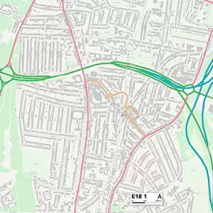
Redbridge E18 2 Map

![]()
Wall Art and Photo Gifts from Map Marketing
Redbridge E18 2 Map
Postcode Sector Map of Redbridge E18 2
Media ID 19969766
Avon Way Bedford Road Beechwood Park Bradwell Close Buckingham Road Byron Avenue Carnarvon Road Chatham Road Chelmsford Road Clarendon Road Cleveland Road Coppice Way Derby Road Grove Crescent Grove End Grove Hill Grove Road Hermitage Close High Road High View Road Hillcrest Road Lansdowne Road Laurel Way Lincoln Road Malmesbury Road Meadow Walk Peel Road Priory Close Queen Mary Avenue Raymond Avenue Redbridge Stanley Road Tavistock Road The Drive Walpole Road Washington Road Woodford Road Wordsworth Avenue Broadwalk
FEATURES IN THESE COLLECTIONS
> Arts
> Artists
> C
> Craig Craig
> Europe
> United Kingdom
> England
> Avon
> Europe
> United Kingdom
> England
> Cleveland
> Map Marketing
> Postcode Sector Maps
> E - London E
> Maps and Charts
> Related Images
MADE IN THE UK
Safe Shipping with 30 Day Money Back Guarantee
FREE PERSONALISATION*
We are proud to offer a range of customisation features including Personalised Captions, Color Filters and Picture Zoom Tools
SECURE PAYMENTS
We happily accept a wide range of payment options so you can pay for the things you need in the way that is most convenient for you
* Options may vary by product and licensing agreement. Zoomed Pictures can be adjusted in the Basket.