Home > Europe > United Kingdom > England > London > Boroughs > Hounslow
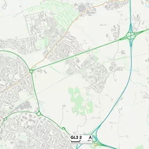
Hounslow TW7 4 Map

![]()
Wall Art and Photo Gifts from Map Marketing
Hounslow TW7 4 Map
Postcode Sector Map of Hounslow TW7 4
Media ID 19980084
Avenue Road Burlington Road Caroline Close Church Road Clifton Road Crawford Close Grove Road Harvard Road Hounslow Jersey Road Jordans Close Meadowbank Close Moreton Avenue Naseby Close Oakley Close Overton Close Palmerston Road Pembroke Place Pevensey Close Sidmouth Avenue Spencer Road Spring Grove St Andrews Close St Christophers Close St Marys Crescent Star Road The Close The Drive The Grove Thornbury Avenue Thornbury Road Villiers Road Vincent Road Witham Road Osterley
FEATURES IN THESE COLLECTIONS
> Europe
> United Kingdom
> England
> London
> Boroughs
> Hounslow
> Europe
> United Kingdom
> Scotland
> Fife
> St Andrews
> Europe
> United Kingdom
> Wales
> Pembrokeshire
> Pembroke
> Map Marketing
> Postcode Sector Maps
> TW - Twickenham
> Maps and Charts
> Related Images
> Maps and Charts
> Star Charts
MADE IN THE UK
Safe Shipping with 30 Day Money Back Guarantee
FREE PERSONALISATION*
We are proud to offer a range of customisation features including Personalised Captions, Color Filters and Picture Zoom Tools
SECURE PAYMENTS
We happily accept a wide range of payment options so you can pay for the things you need in the way that is most convenient for you
* Options may vary by product and licensing agreement. Zoomed Pictures can be adjusted in the Basket.