Home > Europe > United Kingdom > England > London > Towns > Lower Place
Horsham RH20 1 Map

![]()
Wall Art and Photo Gifts from Map Marketing
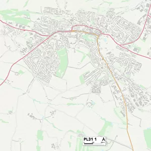
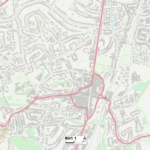
Horsham RH20 1 Map
Postcode Sector Map of Horsham RH20 1
Media ID 19979632
Beacon Hill Bell Close Birch Court Brook Lane Bury Bury Road Chapel Close Chestnut Walk Church Hill Church Lane Church Place Churchfield Fairmead Close Greenfield Hanover Close Harwood Close Hill Farm Lane Horsham Houghton Lane Kings Lane London Road Lower Street Masons Way Old London Road Old Rectory Lane Park Lane River Lane Riverside Sandy Lane School Close School Lane Shackleton Close Silverdale Station Approach Station Road Sutton The Gardens The Hollow The Street The Willows Upper Street Waters Edge Woodcote Lane Wren Close Bignor Bury Hill Coates Fittleworth Maple Leaf Pulborough The Fleet West Burton
FEATURES IN THESE COLLECTIONS
> Animals
> Birds
> Waterfowl
> Swans
> Black Swan
> Animals
> Mammals
> Muridae
> Little Wood Mouse
> Arts
> Landscape paintings
> Waterfall and river artworks
> River artworks
> Arts
> Portraits
> Pop art gallery
> Street art portraits
> Europe
> United Kingdom
> England
> London
> Boroughs
> Sutton
> Europe
> United Kingdom
> England
> London
> Related Images
> Europe
> United Kingdom
> England
> London
> Towns
> Church End
> Europe
> United Kingdom
> England
> London
> Towns
> Lower Place
> Europe
> United Kingdom
> England
> London
> Towns
> Sutton
> Europe
> United Kingdom
> England
> London
> Towns
> West Hill
> Map Marketing
> Postcode Sector Maps
> RH - Redhill
MADE IN THE UK
Safe Shipping with 30 Day Money Back Guarantee
FREE PERSONALISATION*
We are proud to offer a range of customisation features including Personalised Captions, Color Filters and Picture Zoom Tools
SECURE PAYMENTS
We happily accept a wide range of payment options so you can pay for the things you need in the way that is most convenient for you
* Options may vary by product and licensing agreement. Zoomed Pictures can be adjusted in the Basket.