Home > Europe > United Kingdom > England > London > Boroughs > Hillingdon
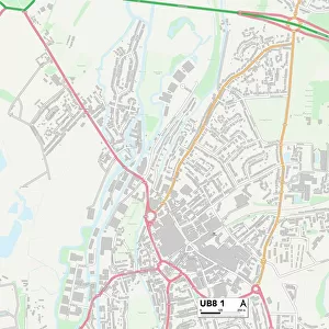
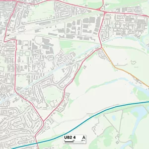
Hillingdon UB8 2 Map

![]()
Wall Art and Photo Gifts from Map Marketing
Hillingdon UB8 2 Map
Postcode Sector Map of Hillingdon UB8 2
Media ID 19980114
Alexandra Road Andover Close Arundel Road Ashley Road Bridge Road Chancel Close Church Close Church Lane Cornfield Close Cotswold Close Cowley Road Derby Road Dukes Way Enfield Close Eskdale Road Ferndale Crescent Florence Way Glebe Road Heritage Close High Road High Street Hillingdon Hilton Close Hinton Road Hogarth Close Kew Close Kings Road Lawn Road Mill Avenue Millennium Close Norton Road Old Mill Close Old Mill Lane Queens Road Redfern Close Robins Close Rockingham Close Rockingham Road Salisbury Road Shepherds Close Sidney Close Spencer Close St Johns Close St Johns Road Stanley Close Stirling Close The Greenway The Lynch Victoria Road Walford Road Wallingford Road Waterloo Road Waterside Wellington Road Whitebeam Close Whitehall Road
FEATURES IN THESE COLLECTIONS
> Animals
> Birds
> Bucerotiformes
> Typical Hornbills
> Black Hornbill
> Arts
> Artists
> H
> Florence Hardy
> Arts
> Portraits
> Pop art gallery
> Street art portraits
> Europe
> United Kingdom
> England
> London
> Boroughs
> Enfield
> Europe
> United Kingdom
> England
> London
> Boroughs
> Hillingdon
> Europe
> United Kingdom
> England
> London
> Sights
> Victoria Park
> Europe
> United Kingdom
> Scotland
> Stirlingshire
> Stirling
> Map Marketing
> Postcode Sector Maps
> UB - Uxbridge
> Map Marketing
> UK Maps
> Maps and Charts
> Related Images
MADE IN THE UK
Safe Shipping with 30 Day Money Back Guarantee
FREE PERSONALISATION*
We are proud to offer a range of customisation features including Personalised Captions, Color Filters and Picture Zoom Tools
SECURE PAYMENTS
We happily accept a wide range of payment options so you can pay for the things you need in the way that is most convenient for you
* Options may vary by product and licensing agreement. Zoomed Pictures can be adjusted in the Basket.