Home > Europe > United Kingdom > England > London > Boroughs > Hillingdon
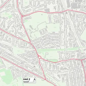
Hillingdon HA6 1 Map

![]()
Wall Art and Photo Gifts from Map Marketing
Hillingdon HA6 1 Map
Postcode Sector Map of Hillingdon HA6 1
Media ID 19970559
Addison Close Addison Way Ashurst Close Barker Close Bennett Close Central Way Chester Road Chestnut Avenue Church Close Church Road Colchester Road Cranbourne Road Emmanuel Road Forge Lane Green Lane High Street Highfield Road Highland Road Hillingdon Hillside Crescent Hillside Gardens Hillside Road Jasmin Close Lichfield Road Lincoln Road Lynwood Drive Northwood Norwich Road Oakdale Avenue Potter Street Reginald Road Rickmansworth Road Rochester Road Stanley Road Station Approach The Drive Townsend Way Waverley Gardens Winchester Road Windsor Close York Road Ferndown
FEATURES IN THESE COLLECTIONS
> Arts
> Portraits
> Pop art gallery
> Street art portraits
> Europe
> United Kingdom
> England
> London
> Boroughs
> Hillingdon
> Map Marketing
> Postcode Sector Maps
> HA - Harrow
> Maps and Charts
> Related Images
> North America
> United States of America
> New York
> New York
> Maps
> North America
> United States of America
> New York
> New York
> Sights
> Wall Street
> North America
> United States of America
> New York
> Related Images
> North America
> United States of America
> New York
> Rochester
MADE IN THE UK
Safe Shipping with 30 Day Money Back Guarantee
FREE PERSONALISATION*
We are proud to offer a range of customisation features including Personalised Captions, Color Filters and Picture Zoom Tools
SECURE PAYMENTS
We happily accept a wide range of payment options so you can pay for the things you need in the way that is most convenient for you
* Options may vary by product and licensing agreement. Zoomed Pictures can be adjusted in the Basket.