Home > Europe > United Kingdom > England > Hampshire > Denmead
Hampshire RG26 4 Map

![]()
Wall Art and Photo Gifts from Map Marketing
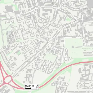
Hampshire RG26 4 Map
Postcode Sector Map of Hampshire RG26 4
Media ID 19979622
Ashurst Close Birch Road Bishops Close Bond Close Burnham Road Franklin Avenue Furze Road Glendale Road Hampshire Heather Drive Meon Close Millers Road Mount Pleasant Mount Pleasant Drive Newchurch Road Newtown Oak Tree Close Plantation Road Priors Road Royal Gardens Sandford Road Silverdale Road Southdown Road The Beeches The Burrows The Copse The Oaks Willow Road Pleasant Hill Stanfield
FEATURES IN THESE COLLECTIONS
> Europe
> United Kingdom
> England
> Hampshire
> Ashurst
> Europe
> United Kingdom
> England
> Hampshire
> Beech
> Europe
> United Kingdom
> England
> Hampshire
> Bordon
> Europe
> United Kingdom
> England
> Hampshire
> Brook
> Europe
> United Kingdom
> England
> Hampshire
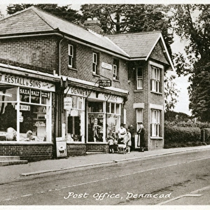
> Denmead
> Europe
> United Kingdom
> England
> Hampshire
> Greywell
> Europe
> United Kingdom
> England
> Hampshire
> Meon
> Europe
> United Kingdom
> England
> Hampshire
> Newtown
> Europe
> United Kingdom
> England
> Hampshire
> Purbrook
> Map Marketing
> Postcode Sector Maps
> RG - Reading
MADE IN THE UK
Safe Shipping with 30 Day Money Back Guarantee
FREE PERSONALISATION*
We are proud to offer a range of customisation features including Personalised Captions, Color Filters and Picture Zoom Tools
SECURE PAYMENTS
We happily accept a wide range of payment options so you can pay for the things you need in the way that is most convenient for you
* Options may vary by product and licensing agreement. Zoomed Pictures can be adjusted in the Basket.