Home > Europe > United Kingdom > Scotland > Fife > St Andrews
Elmbridge KT11 3 Map

![]()
Wall Art and Photo Gifts from Map Marketing
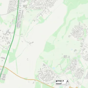
Elmbridge KT11 3 Map
Postcode Sector Map of Elmbridge KT11 3
Media ID 19973082
Aspen Close Avenue Road Bray Road Bridge Road Church Street Cobham Road Deacon Close Downside Downside Road Elm Grove Road Elmbridge Horsley Road Lambourne Drive Lodge Close Middleton Road Pipers Close River Lane St Andrews Walk Station Road Stoke Road Vincent Road Winston Drive Woodlands Lane River Hill
FEATURES IN THESE COLLECTIONS
> Arts
> Landscape paintings
> Waterfall and river artworks
> River artworks
> Arts
> Portraits
> Pop art gallery
> Street art portraits
> Europe
> United Kingdom
> Scotland
> Fife
> St Andrews
> Map Marketing
> Postcode Sector Maps
> KT - Kingston upon Thames
> Maps and Charts
> Related Images
MADE IN THE UK
Safe Shipping with 30 Day Money Back Guarantee
FREE PERSONALISATION*
We are proud to offer a range of customisation features including Personalised Captions, Color Filters and Picture Zoom Tools
SECURE PAYMENTS
We happily accept a wide range of payment options so you can pay for the things you need in the way that is most convenient for you
* Options may vary by product and licensing agreement. Zoomed Pictures can be adjusted in the Basket.