Home > Europe > United Kingdom > England > Birmingham > Area > Hamstead
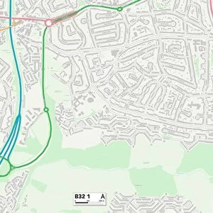
Birmingham B20 1 Map

![]()
Wall Art and Photo Gifts from Map Marketing
Birmingham B20 1 Map
Postcode Sector Map of Birmingham B20 1
Media ID 19965333
Beechwood Birmingham Friary Road Hawthorn Park High Trees Holly Gardens Millfield Road Park Hill Drive Parkside Road Sunningdale Close The Spinney Underwood Road Vernon Avenue Westover Road Woodcroft Avenue Woodend Garden Grove
FEATURES IN THESE COLLECTIONS
> Animals
> Birds
> Cassowaries
> Related Images
> Europe
> United Kingdom
> England
> Birmingham
> Area
> Browns Green
> Europe
> United Kingdom
> England
> Birmingham
> Area
> Hall Green
> Europe
> United Kingdom
> England
> Birmingham
> Area
> Hamstead
> Europe
> United Kingdom
> Wales
> Pembrokeshire
> St Davids
> Map Marketing
> Postcode Sector Maps
> B - Birmingham
> Maps and Charts
> Related Images
MADE IN THE UK
Safe Shipping with 30 Day Money Back Guarantee
FREE PERSONALISATION*
We are proud to offer a range of customisation features including Personalised Captions, Color Filters and Picture Zoom Tools
SECURE PAYMENTS
We happily accept a wide range of payment options so you can pay for the things you need in the way that is most convenient for you
* Options may vary by product and licensing agreement. Zoomed Pictures can be adjusted in the Basket.