Home > Europe > United Kingdom > England > London > Boroughs > Barnet
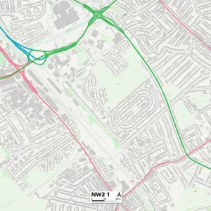
Barnet NW11 8 Map

![]()
Wall Art and Photo Gifts from Map Marketing
Barnet NW11 8 Map
Postcode Sector Map of Barnet NW11 8
Media ID 19977285
Accommodation Road Armitage Road Barnet Dunstan Road Mendip Drive Pentland Close Ridge Hill The Ridgeway The Riding The Vale Wayside Woodstock Road
FEATURES IN THESE COLLECTIONS
> Europe
> United Kingdom
> England
> London
> Boroughs
> Barnet
> Map Marketing
> Postcode Sector Maps
> NW - London NW
> Maps and Charts
> Related Images
MADE IN THE UK
Safe Shipping with 30 Day Money Back Guarantee
FREE PERSONALISATION*
We are proud to offer a range of customisation features including Personalised Captions, Color Filters and Picture Zoom Tools
SECURE PAYMENTS
We happily accept a wide range of payment options so you can pay for the things you need in the way that is most convenient for you
* Options may vary by product and licensing agreement. Zoomed Pictures can be adjusted in the Basket.