Home > Arts > Artists > K > Johannes van Keulen
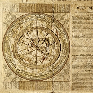
Sea chart of the southern part of the North Sea and part of the east coast of England

![]()
Wall Art and Photo Gifts from Liszt Collection
Sea chart of the southern part of the North Sea and part of the east coast of England
Sea chart of the southern part of the North Sea and part of the east coast of England, Gerard van Keulen, Johannes van Keulen (I), unknown, 1688 - 1803
Liszt Collection of nineteenth-century engravings and images to browse and enjoy
Media ID 12716431
© Quint Lox Limited
Address Cherubs Coast Coasts Compass Compass Roses Decorated Dignitaries East East Coast Flanders Holland Meuse North North Sea Over Roses Scale Sea Chart Shores Southern Zeeland Chart River Meuse
FEATURES IN THESE COLLECTIONS
> Animals
> Insects
> Hemiptera
> Rose Scale
> Arts
> Artists
> K
> Johannes van Keulen
> Europe
> France
> Canton
> Meuse
> Europe
> United Kingdom
> England
> Maps
> Europe
> United Kingdom
> England
> Rivers
> Maps and Charts
> World
EDITORS COMMENTS
This print showcases a remarkable sea chart from the late 17th to early 18th century, depicting the southern part of the North Sea and a section of England's east coast. Created by renowned cartographers Gerard van Keulen and Johannes van Keulen (I), this map is an exquisite example of their mastery in geographical representation. The intricate details on this sea chart are truly awe-inspiring. The shores of Holland, Zeeland, Flanders, and the east coast of England are meticulously illustrated, providing valuable insights into maritime navigation during that era. Compass roses elegantly adorn the corners, guiding sailors with their cardinal directions. What sets this particular map apart is its ornate decoration. Cherubs gracefully hover above dignitaries who seem engaged in deep conversation about nautical affairs. This artistic touch adds a sense of grandeur to an already impressive piece. Notably featured on this sea chart is the Bet Waiver River Meuse—a vital waterway for trade and transportation at that time—highlighting its significance in connecting various regions depicted on the map. With meticulous attention to detail and an expertly crafted scale, Gerard van Keulen and Johannes van Keulen (I) have created a masterpiece that not only serves as a navigational tool but also stands as a testament to their expertise in cartography. Quint Lox's skillful photography captures every nuance of this historical artifact from the Liszt Collection, allowing viewers to appreciate its beauty and importance even centuries after its creation.
MADE IN THE UK
Safe Shipping with 30 Day Money Back Guarantee
FREE PERSONALISATION*
We are proud to offer a range of customisation features including Personalised Captions, Color Filters and Picture Zoom Tools
SECURE PAYMENTS
We happily accept a wide range of payment options so you can pay for the things you need in the way that is most convenient for you
* Options may vary by product and licensing agreement. Zoomed Pictures can be adjusted in the Basket.