Home > Arts > Artists > K > Johannes van Keulen
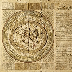
Sea chart of the coast of Ireland, Scotland, England and France, Jan Luyken, Anonymous

![]()
Wall Art and Photo Gifts from Liszt Collection
Sea chart of the coast of Ireland, Scotland, England and France, Jan Luyken, Anonymous
Sea chart of the coast of Ireland, Scotland, England and France, Jan Luyken, Anonymous, Johannes van Keulen (I), 1681 - 1803
Liszt Collection of nineteenth-century engravings and images to browse and enjoy
Media ID 12716403
© Quint Lox Limited
1681 1803 Cartouche Coast Coasts Compass Compass Roses Cowherd French Miles Herding Herdsman Herdswoman Ireland Jan Luyken Johannes Van Keulen North Roses Sea Chart Sheep Shepherd Shepherdess Sleeping Anonymous Chart Doze
FEATURES IN THESE COLLECTIONS
> Animals
> Mammals
> Bovidae
> Sheep
> Arts
> Artists
> K
> Johannes van Keulen
> Arts
> Artists
> L
> Jan Luyken
> Europe
> France
> Sport
> Sailing
> Europe
> Republic of Ireland
> Maps
> Europe
> United Kingdom
> England
> Maps
> Europe
> United Kingdom
> Scotland
> Maps
EDITORS COMMENTS
In this print titled "Sea chart of the coast of Ireland, Scotland, England and France" we are transported back in time to an era when cartography was a true art form. The intricate details and exquisite craftsmanship depicted in this map by Jan Luyken, Anonymous, and Johannes van Keulen (I) from 1681-1803 leave us in awe. As our eyes wander across the vast expanse of the chart, we notice various compass roses guiding sailors through treacherous waters. But amidst these navigational aids lies a peaceful scene that captures our attention - a shepherdess peacefully herding her flock along the rugged coastline. The sheep doze beneath her watchful gaze as she rests on a grassy knoll. Her presence brings a sense of tranquility to this otherwise bustling world of geographical exploration. It is as if time stands still for this moment, allowing us to appreciate both the beauty of nature and the ingenuity of human invention. The inclusion of French miles on the cartouche reminds us that maps not only serve practical purposes but also act as cultural artifacts connecting different regions and nations. This sea chart serves as a testament to the interconnectedness between Ireland, Scotland, England, and France during this period. Quint Lox's skillful capture preserves every minute detail with precision and clarity. Through his lens, we can almost feel the salty breeze coming off the sea while marveling at how far we have come in terms of navigation technology since those early days
MADE IN THE UK
Safe Shipping with 30 Day Money Back Guarantee
FREE PERSONALISATION*
We are proud to offer a range of customisation features including Personalised Captions, Color Filters and Picture Zoom Tools
SECURE PAYMENTS
We happily accept a wide range of payment options so you can pay for the things you need in the way that is most convenient for you
* Options may vary by product and licensing agreement. Zoomed Pictures can be adjusted in the Basket.