Home > Arts > Artists > K > Johannes van Keulen
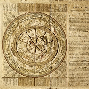
Sea chart of part of the coast of Ireland, England, France and Spain

![]()
Wall Art and Photo Gifts from Liszt Collection
Sea chart of part of the coast of Ireland, England, France and Spain
Liszt Collection of nineteenth-century engravings and images to browse and enjoy
Media ID 12716627
© Quint Lox Limited
Amores Amoretti Atlases Cartouche Claes Jansz Voogt Coast Compass Compass Rose Cupids French Miles Ireland Johannes Van Keulen Maps Miles North Putti Rose Scale Sea Chart Spain Spanish Biscay Chart
FEATURES IN THESE COLLECTIONS
> Animals
> Insects
> Hemiptera
> Rose Scale
> Arts
> Artists
> K
> Johannes van Keulen
> Europe
> France
> Sport
> Sailing
> Europe
> Republic of Ireland
> Maps
> Europe
> United Kingdom
> England
> Maps
> Maps and Charts
> Spain
EDITORS COMMENTS
This print showcases a remarkable sea chart of the coastlines of Ireland, England, France, and Spain. Created by renowned cartographers Claes Jansz Voogt and Johannes van Keulen between 1678 and 1715, this exquisite piece of art combines elements of geography, history, and beauty. The intricate details on this map are truly awe-inspiring. Cupids, amores, amoretti, and putti gracefully adorn the edges while a compass rose points towards the north. The cartouche adds an elegant touch to the composition with its German, Spanish, English, and French inscriptions. Every line on this chart tells a story - from the Bay of Biscay to the coastal outlines meticulously drawn in stunning accuracy. It is as if one can almost hear the crashing waves against these shores just by gazing at it. The scale marked in French miles allows us to imagine sailors navigating through these treacherous waters centuries ago. This sea chart not only serves as a navigational tool but also as a testament to human curiosity about our world's vast oceans. Quint Lox has masterfully captured this historical artifact through his lens. His attention to detail brings out every nuance present in this print – making it come alive for all who behold it. Whether you are fascinated by maps or simply appreciate fine artistry that transcends time itself; this print is sure to captivate your imagination and transport you back in time to an era when exploration was paramount
MADE IN THE UK
Safe Shipping with 30 Day Money Back Guarantee
FREE PERSONALISATION*
We are proud to offer a range of customisation features including Personalised Captions, Color Filters and Picture Zoom Tools
SECURE PAYMENTS
We happily accept a wide range of payment options so you can pay for the things you need in the way that is most convenient for you
* Options may vary by product and licensing agreement. Zoomed Pictures can be adjusted in the Basket.