Home > Arts > Artists > K > Johannes van Keulen
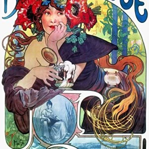
Sea chart of the coast of Holland between Texel and the Meuse, Jan Luyken, Anonymous

![]()
Wall Art and Photo Gifts from Liszt Collection
Sea chart of the coast of Holland between Texel and the Meuse, Jan Luyken, Anonymous
Sea chart of the coast of Holland between Texel and the Meuse, Jan Luyken, Anonymous, Johannes van Keulen (I), 1681 - 1803
Liszt Collection of nineteenth-century engravings and images to browse and enjoy
Media ID 12716399
© Quint Lox Limited
1681 1803 Address Amores Amoretti Cartouche Cheese Coast Compass Compass Roses Cupids Farmer French Miles Holland Jan Luyken Johannes Van Keulen Meuse North Putti Roses Scale Sea Chart Texel Anonymous Chart Cheeses Churning
FEATURES IN THESE COLLECTIONS
> Animals
> Insects
> Hemiptera
> Rose Scale
> Arts
> Artists
> K
> Johannes van Keulen
> Arts
> Artists
> L
> Jan Luyken
> Europe
> France
> Canton
> Meuse
> Maps and Charts
> World
EDITORS COMMENTS
This print showcases a remarkable sea chart of the picturesque coast of Holland, stretching from Texel to the Meuse. Created by the talented Jan Luyken and an anonymous artist, this exquisite piece of cartography takes us back in time to the years between 1681 and 1803. The map itself is a true work of art, intricately detailed with compass roses indicating direction and a beautifully designed cartouche that adds elegance to its overall aesthetic. Amidst this nautical masterpiece, one can spot delightful cupids or putti engaging in various activities such as churning cheese - a charming glimpse into Dutch culture. Every element on this sea chart serves a purpose; it not only provides geographical information but also tells stories about life along the coast. The presence of a churning farmer signifies the importance of agriculture in these coastal regions while French miles indicate international trade connections. As we delve deeper into Quint Lox's expertly captured photo print, we are transported to an era where maps were not just tools for navigation but also works of art that celebrated both land and sea. This image truly encapsulates the beauty and significance behind historical cartography, reminding us how our understanding of geography has evolved over centuries.
MADE IN THE UK
Safe Shipping with 30 Day Money Back Guarantee
FREE PERSONALISATION*
We are proud to offer a range of customisation features including Personalised Captions, Color Filters and Picture Zoom Tools
SECURE PAYMENTS
We happily accept a wide range of payment options so you can pay for the things you need in the way that is most convenient for you
* Options may vary by product and licensing agreement. Zoomed Pictures can be adjusted in the Basket.