
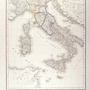
Map Le cours du Po dans le duchA de Ferrare et les etats de Venise

crop_landscape
Photo Prints
Jigsaw Puzzles
Poster Prints
Canvas Prints
Fine Art Prints
Mounted Prints
Metal Prints
Cards
Home Decor
![]()
Wall Art and Photo Gifts from Liszt Collection
Map Le cours du Po dans le duchA de Ferrare et les etats de Venise
Map, Le cours du Po dans le duche de Ferrare et les etats de Venise, Placide de Sainte Helene (1648-1734), Copperplate print
Liszt Collection of nineteenth-century engravings and images to browse and enjoy
Media ID 19586551
© Artokoloro
1648 1734 Copperplate Print Placide De Sainte Hélène
MADE IN THE UK
Safe Shipping with 30 Day Money Back Guarantee
FREE PERSONALISATION*
We are proud to offer a range of customisation features including Personalised Captions, Color Filters and Picture Zoom Tools
SECURE PAYMENTS
We happily accept a wide range of payment options so you can pay for the things you need in the way that is most convenient for you
* Options may vary by product and licensing agreement. Zoomed Pictures can be adjusted in the Basket.
Beautiful Photo Prints and Gifts
Professionally Printed
Photo Prints are in stock
Professional quality finish
Made with high-grade materials
Carefully packed to aid safe arrival
Related Images


+
Shipping
+
Choices
+
Reviews
+