Home > Africa > The Gambia > Maps
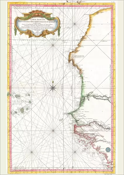
Poster Print : 1865, Bellin Sea Chart of Western Africa, Senegal, Gambia, Guinea, etc. topography


![]()
Poster Prints from Liszt Collection
1865, Bellin Sea Chart of Western Africa, Senegal, Gambia, Guinea, etc. topography
1865, Bellin Sea Chart of Western Africa, Senegal, Gambia, Guinea, etc
Liszt Collection of nineteenth-century engravings and images to browse and enjoy
Media ID 14006080
© Artokoloro Quint Lox Limited
Gambia Guinea Senegal Antique Map Atlas Chart Geographic Latitude Longitude Mappa Mundi Old Antique Plan Old Antique View Old Map Ols Antique Map Rare Old Maps Topo
A1 (84.1 x 59.4cm) Poster Print
Step back in time with our stunning Media Storehouse Poster Print of the 1865 Bellin Sea Chart of Western Africa. This historic map, part of the renowned Liszt Collection, meticulously depicts the topography of Senegal, Gambia, Guinea, and the surrounding regions during a pivotal period in African exploration. Add an air of sophistication and intrigue to any space with this beautiful, high-quality poster print. Perfect for history enthusiasts, cartography aficionados, or anyone looking to add a touch of the past to their décor. Order now and bring a piece of history into your home or office.
A1 Poster (84.1 x 59.4cm, 33.1" x 23.4" inches) printed on 170gsm Satin Poster Paper. Securely packaged, rolled and inserted into a strong mailing tube and shipped tracked. Poster Prints are of comparable archival quality to our Photographic prints, they are simply printed on thinner Poster Paper. Whilst we only use Photographic Prints in our frames, you can frame Poster Prints if they are carefully supported to prevent sagging over time.
Poster prints are budget friendly enlarged prints in standard poster paper sizes (A0, A1, A2, A3 etc). Whilst poster paper is sometimes thinner and less durable than our other paper types, they are still ok for framing and should last many years. Our Archival Quality Photo Prints and Fine Art Paper Prints are printed on higher quality paper and the choice of which largely depends on your budget.
Estimated Image Size (if not cropped) is 53.3cm x 84.1cm (21" x 33.1")
Estimated Product Size is 59.4cm x 84.1cm (23.4" x 33.1")
These are individually made so all sizes are approximate
Artwork printed orientated as per the preview above, with portrait (vertical) orientation to match the source image.
FEATURES IN THESE COLLECTIONS
> Africa
> The Gambia
> Maps
> Maps and Charts
> Early Maps
> Maps and Charts
> World
EDITORS COMMENTS
This print showcases a remarkable piece of history - the 1865 Bellin Sea Chart of Western Africa. With its intricate details and stunning topography, this chart offers a glimpse into the past, specifically focusing on Senegal, Gambia, Guinea, and other regions in Western Africa. The artistry behind this vintage map is evident as it beautifully illustrates the geographic features of the land. The carefully plotted grid lines denote latitude and longitude coordinates, allowing for precise navigation across these African territories. Its antique charm adds to its allure, making it an ideal decorative piece for any history enthusiast or travel lover. As we gaze upon this aged treasure from centuries ago, we are transported back in time to an era of exploration and discovery. This rare old map not only serves as a testament to human curiosity but also provides valuable insights into how our understanding of geography has evolved over time. Whether displayed in a study or showcased in a gallery space dedicated to historical artifacts, this Bellin Sea Chart is sure to captivate viewers with its rich heritage and artistic craftsmanship. It reminds us that even though technology has transformed navigation today, there is still immense value in appreciating the beauty and significance of ancient cartography like this one from Liszt Collection's archives.
MADE IN THE UK
Safe Shipping with 30 Day Money Back Guarantee
FREE PERSONALISATION*
We are proud to offer a range of customisation features including Personalised Captions, Color Filters and Picture Zoom Tools
SECURE PAYMENTS
We happily accept a wide range of payment options so you can pay for the things you need in the way that is most convenient for you
* Options may vary by product and licensing agreement. Zoomed Pictures can be adjusted in the Basket.