Home > Africa > The Gambia > Maps
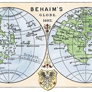
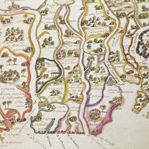
Photographic Print : 1848, Levasseur Map of Senegal, Gambia and Madagascar, topography, cartography, geography


![]()
Photo Prints from Liszt Collection
1848, Levasseur Map of Senegal, Gambia and Madagascar, topography, cartography, geography
1848, Levasseur Map of Senegal, Gambia and Madagascar
Liszt Collection of nineteenth-century engravings and images to browse and enjoy
Media ID 14005144
© Artokoloro Quint Lox Limited
1848 Antique Map Atlas Chart Geographic Latitude Longitude Mappa Mundi Old Antique Plan Old Antique View Old Map Ols Antique Map Rare Old Maps Topo
10"x8" (25x20cm) Photo Print
Discover the intriguing history of exploration with our exquisite 1848 Levasseur Map of Senegal, Gambia, and Madagascar print from the renowned Liszt Collection. This stunning piece showcases the topography, cartography, and geography of these fascinating regions during a pivotal period in world history. The intricate details of this rare map transport you back in time, providing a captivating glimpse into the geographical knowledge of the 19th century. Add this historical treasure to your home or office to ignite curiosity and elevate your decor. Each print is meticulously crafted using archival-quality materials, ensuring a long-lasting and beautiful addition to your collection.
Printed on archival quality paper for unrivalled stable artwork permanence and brilliant colour reproduction with accurate colour rendition and smooth tones. Printed on professional 234gsm Fujifilm Crystal Archive DP II paper. 10x8 for landscape images, 8x10 for portrait images.
Our Photo Prints are in a large range of sizes and are printed on Archival Quality Paper for excellent colour reproduction and longevity. They are ideal for framing (our Framed Prints use these) at a reasonable cost. Alternatives include cheaper Poster Prints and higher quality Fine Art Paper, the choice of which is largely dependant on your budget.
Estimated Image Size (if not cropped) is 25.4cm x 18cm (10" x 7.1")
Estimated Product Size is 25.4cm x 20.3cm (10" x 8")
These are individually made so all sizes are approximate
Artwork printed orientated as per the preview above, with landscape (horizontal) orientation to match the source image.
FEATURES IN THESE COLLECTIONS
> Africa
> The Gambia
> Maps
> Africa
> Madagascar
> Maps
> Europe
> France
> Canton
> Landes
> Historic
> Space exploration
> Maps and Charts
> Early Maps
> Maps and Charts
> World
EDITORS COMMENTS
This print showcases the exquisite "1848, Levasseur Map of Senegal, Gambia and Madagascar". A true masterpiece in topography, cartography, and geography, this vintage map takes us on a journey through time. The intricate details and precision of this ancient artifact allow us to explore these regions with unparalleled accuracy. The artist's skillful hand has beautifully illustrated the landforms and geographic features of Senegal, Gambia, and Madagascar. From the rolling hills to the meandering rivers, every contour is meticulously depicted. This map serves as a valuable resource for travelers seeking to navigate these lands or historians delving into their rich past. With its grid lines marking latitude and longitude coordinates like an elaborate geometric puzzle, this map becomes a window into history. Its presence evokes a sense of nostalgia for bygone eras when exploration was at its peak. As we gaze upon it today, we are reminded of the countless journeys embarked upon by brave adventurers who used maps like these as their guiding stars. This rare old map holds immense historical significance; it is not merely paper but rather a testament to human curiosity and discovery. Its decorative elements add an artistic touch that elevates it beyond mere navigation tool status. It stands as a reminder of our planet's vastness and diversity while also serving as an homage to those who paved the way for our understanding of the world.
MADE IN THE UK
Safe Shipping with 30 Day Money Back Guarantee
FREE PERSONALISATION*
We are proud to offer a range of customisation features including Personalised Captions, Color Filters and Picture Zoom Tools
SECURE PAYMENTS
We happily accept a wide range of payment options so you can pay for the things you need in the way that is most convenient for you
* Options may vary by product and licensing agreement. Zoomed Pictures can be adjusted in the Basket.