Home > Africa > Cape Verde > Maps
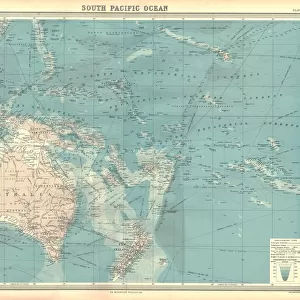
1771, Bonne Map of the Guinea Coast of West Africa and the Cape Verde Islands, Rigobert

![]()
Wall Art and Photo Gifts from Liszt Collection
1771, Bonne Map of the Guinea Coast of West Africa and the Cape Verde Islands, Rigobert
1771, Bonne Map of the Guinea Coast of West Africa and the Cape Verde Islands, Rigobert Bonne 1727 - 1794, one of the most important cartographers of the late 18th century
Liszt Collection of nineteenth-century engravings and images to browse and enjoy
Media ID 14006713
© Artokoloro Quint Lox Limited
1771 Rigobert Bonne 1727 1794 Rigobert Bonne 1727 – 1794 Rigobert Bonne 17271794 Antique Map Atlas Chart Geographic Latitude Longitude Mappa Mundi Old Antique Plan Old Antique View Old Map Ols Antique Map Rare Old Maps Topo
FEATURES IN THESE COLLECTIONS
> Africa
> Cape Verde
> Maps
> Maps and Charts
> Early Maps
> Maps and Charts
> World
EDITORS COMMENTS
This vintage print showcases the remarkable 1771 Bonne Map of the Guinea Coast of West Africa and the Cape Verde Islands, created by Rigobert Bonne (1727-1794), a renowned cartographer of the late 18th century. With its intricate topography and detailed cartography, this illustration offers a fascinating glimpse into the geography and land formations of this region during that era. The map's grid system, marked with latitude and longitude lines, provides a precise navigational tool for travelers and explorers alike. Its historical significance lies in its representation of an ancient world, capturing a time when exploration and discovery were at their peak. Printed on aged paper, this decorative piece exudes an air of nostalgia while serving as a testament to Bonne's expertise in mapmaking. The artistic rendering beautifully combines artistry with scientific accuracy, making it not only visually appealing but also highly informative. Whether you are an avid collector or simply intrigued by history, this antique map transports you back in time to an era when geographical knowledge was expanding rapidly. It serves as a memento of past journeys undertaken by brave adventurers who sought to uncover new regions across our vast planet.
MADE IN THE UK
Safe Shipping with 30 Day Money Back Guarantee
FREE PERSONALISATION*
We are proud to offer a range of customisation features including Personalised Captions, Color Filters and Picture Zoom Tools
SECURE PAYMENTS
We happily accept a wide range of payment options so you can pay for the things you need in the way that is most convenient for you
* Options may vary by product and licensing agreement. Zoomed Pictures can be adjusted in the Basket.