Home > Asia > Singapore > Maps
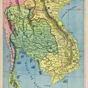
1770, Bonne Map of India, Southeast Asia and The East Indies, Thailand, Borneo, Singapore

![]()
Wall Art and Photo Gifts from Liszt Collection
1770, Bonne Map of India, Southeast Asia and The East Indies, Thailand, Borneo, Singapore
1770, Bonne Map of India, Southeast Asia and The East Indies, Thailand, Borneo, Singapore, Rigobert Bonne 1727 - 1794, one of the most important cartographers of the late 18th century
Liszt Collection of nineteenth-century engravings and images to browse and enjoy
Media ID 14004667
© Artokoloro Quint Lox Limited
1770 Borneo Rigobert Bonne 1727 1794 Rigobert Bonne 1727 – 1794 Rigobert Bonne 17271794 Singapore Thailand Antique Map Atlas Chart Geographic Latitude Longitude Mappa Mundi Old Antique Plan Old Antique View Old Map Ols Antique Map Rare Old Maps Topo
FEATURES IN THESE COLLECTIONS
> Asia
> Singapore
> Singapore
> Asia
> Turkmenistan
> Maps
> Maps and Charts
> Early Maps
> Maps and Charts
> India
> Maps and Charts
> World
EDITORS COMMENTS
This vintage print showcases the remarkable 1770 Bonne Map of India, Southeast Asia, and The East Indies. Created by Rigobert Bonne, one of the most influential cartographers of the late 18th century, this map offers a fascinating glimpse into the geographical knowledge and artistic skill of its time. With intricate topography and precise cartographic details, this illustration provides an invaluable historical record of the region. From Thailand to Borneo and Singapore, it captures a vast expanse of land with accuracy and elegance. The grid lines depicting latitude and longitude add a geometric touch to this ancient map's charm. As we gaze upon this piece from centuries past, we are transported back in time to an era when exploration was at its peak. This decorative print not only serves as a navigational tool but also as a testament to humanity's thirst for discovery. The aged paper texture adds an authentic feel to this historic artwork while reminding us of its significance in our understanding of world history. It is truly a rare gem that allows us to appreciate how far our knowledge has come since then. Whether you are an avid collector or simply fascinated by geography and history, this antique map from Rigobert Bonne is sure to captivate your imagination. Let it take you on a journey through time as you explore the rich cultural heritage embedded within each contour line and landmark depicted on this extraordinary piece.
MADE IN THE UK
Safe Shipping with 30 Day Money Back Guarantee
FREE PERSONALISATION*
We are proud to offer a range of customisation features including Personalised Captions, Color Filters and Picture Zoom Tools
SECURE PAYMENTS
We happily accept a wide range of payment options so you can pay for the things you need in the way that is most convenient for you
* Options may vary by product and licensing agreement. Zoomed Pictures can be adjusted in the Basket.