Home > Europe > Iceland > Maps
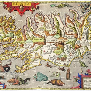
1747, Bowen Map of the North Atlantic Islands, Greenland, Iceland, Faroe Islands

![]()
Wall Art and Photo Gifts from Liszt Collection
1747, Bowen Map of the North Atlantic Islands, Greenland, Iceland, Faroe Islands
1747, Bowen Map of the North Atlantic Islands, Greenland, Iceland, Faroe Islands, Maelstrom
Liszt Collection of nineteenth-century engravings and images to browse and enjoy
Media ID 14004554
© Artokoloro Quint Lox Limited
1747 Greenland Iceland Antique Map Atlas Chart Faroe Islands Geographic Latitude Longitude Maelstrom Mappa Mundi Old Antique Plan Old Antique View Old Map Ols Antique Map Rare Old Maps Topo
FEATURES IN THESE COLLECTIONS
> Maps and Charts
> Early Maps
> Maps and Charts
> World
> North America
> Greenland
> Maps
EDITORS COMMENTS
This print showcases the intricate details of the 1747 Bowen Map of the North Atlantic Islands, including Greenland, Iceland, Faroe Islands, and the treacherous Maelstrom. This vintage map is a testament to the artistry and precision of cartography in its time. The topography and geography of these remote islands are beautifully illustrated on this historic piece. The carefully drawn grid lines denote latitude and longitude, allowing for accurate navigation across these vast expanses. The geometric design adds an element of elegance to this ancient atlas. As we gaze upon this rare old map, we are transported back in time to an era when exploration and discovery were at their peak. It serves as a reminder of how far our understanding of the world has come since then. With its aged appearance and decorative charm, this historical artifact not only appeals to lovers of geography but also captivates those with an appreciation for art and history. Its presence evokes a sense of wonder about our planet's past. Whether displayed in a study or showcased in a gallery space, this antique map sparks curiosity about distant lands that have long fascinated adventurers throughout history. It invites us to embark on our own journey through time as we explore the regions depicted on its weathered surface.
MADE IN THE UK
Safe Shipping with 30 Day Money Back Guarantee
FREE PERSONALISATION*
We are proud to offer a range of customisation features including Personalised Captions, Color Filters and Picture Zoom Tools
SECURE PAYMENTS
We happily accept a wide range of payment options so you can pay for the things you need in the way that is most convenient for you
* Options may vary by product and licensing agreement. Zoomed Pictures can be adjusted in the Basket.