Home > Europe > United Kingdom > England > London > Towns > Paddington
Almost touching JLP01_08_084884

![]()
Wall Art and Photo Gifts from Historic England
Almost touching JLP01_08_084884
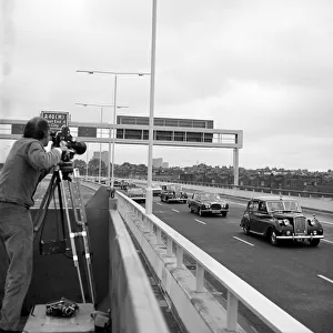
WESTWAY FLYOVER, A40, KENSINGTON AND CHELSEA, GREATER LONDON. A view of the Westway Flyover from below, showing where the deck almost touches the corner of a building on Torquay Street.
Work on site for the Western Avenue Extension began on 1st September 1966, and the Westway as it became known was officially opened on 28th July 1970. The elevated highway connecting the A40 at White City to Marylebone Road in Paddington, at around 2 miles, was the longest in Europe. Consulting engineers G Maunsell & Partners designed the road project for the Greater London Council and John Laing & Son undertook the construction. It was organised into six sections. Sections 1, 4, 5 & 6 formed the main flyover into central London with Sections 2 & 3 being the West Cross Route, running south from the junction in Section 1 near Latimer Road to Shepherds Bush. The management offices for Sections 4 and 5 were located in Torquay Street. This photograph was taken at grid reference TQ
Historic England is the public body that champions and protects England's historic places
Media ID 24782915
© Historic England Archive
1970s Construction Flyover Road Transport
FEATURES IN THESE COLLECTIONS
> Europe
> United Kingdom
> England
> Greater London
> Related Images
> Europe
> United Kingdom
> England
> London
> Boroughs
> Kensington and Chelsea
> Europe
> United Kingdom
> England
> London
> Towns
> Chelsea
> Europe
> United Kingdom
> England
> London
> Towns
> Kensington
> Europe
> United Kingdom
> England
> London
> Towns
> Marylebone
> Europe
> United Kingdom
> England
> London
> Towns
> Paddington
> Historic England
> Industry
> Engineering and Construction
> Building Motorways
> Westway Flyover
EDITORS COMMENTS
This print captures a unique perspective of the Westway Flyover in Kensington and Chelsea, Greater London. The image showcases the moment when the elevated highway's deck almost touches the corner of a building on Torquay Street, creating an intriguing juxtaposition between infrastructure and urban architecture. The Westway Flyover, officially opened on July 28th, 1970, was a significant engineering feat at its time. Spanning approximately two miles, it held the title of being Europe's longest elevated highway. Designed by consulting engineers G Maunsell & Partners for the Greater London Council, this ambitious road project aimed to connect White City to Paddington. Divided into six sections, with Sections 1-4 forming the main flyover into central London and Sections 5-6 comprising the West Cross Route towards Shepherds Bush. Interestingly enough, Torquay Street served as home to management offices for Sections 4 and 5 during construction. This particular photograph offers a glimpse into both history and architectural marvels that shaped London's landscape. Taken from below at grid reference TQ2555981658 by Historic England Archive (not affiliated with any company), it serves as a testament to human ingenuity in transforming urban spaces while preserving their unique character. As we admire this image captured by Joh from Historic England Archive (without mentioning commercial use), let us appreciate how infrastructure can seamlessly blend with our surroundings while leaving an indelible mark on our cityscapes.
MADE IN THE UK
Safe Shipping with 30 Day Money Back Guarantee
FREE PERSONALISATION*
We are proud to offer a range of customisation features including Personalised Captions, Color Filters and Picture Zoom Tools
FREE COLORIZATION SERVICE
You can choose advanced AI Colorization for this picture at no extra charge!
SECURE PAYMENTS
We happily accept a wide range of payment options so you can pay for the things you need in the way that is most convenient for you
* Options may vary by product and licensing agreement. Zoomed Pictures can be adjusted in the Basket.