Home > Europe > United Kingdom > England > London > Sights > New River
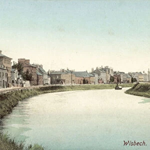
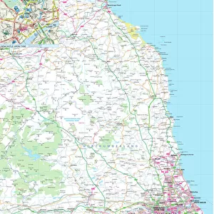
Plan of the Wash, between the Coasts of Norfolk and Lincolnshire, 1850. Creator: Unknown

![]()
Wall Art and Photo Gifts from Heritage Images
Plan of the Wash, between the Coasts of Norfolk and Lincolnshire, 1850. Creator: Unknown
Plan of the Wash, between the Coasts of Norfolk and Lincolnshire, 1850. Map showing the proposed new general outfall and land to be reclaimed in the...Norfolk Estuary, or Metaris Aestuarum...that broad open space of sands and channels, entirely covered at high tide...'. A civil engineering project to divert the course of the River Ouse and enable land reclamation, was undertaken by the Norfolk Estuary Company. Within the memory of persons still living, much of the district now arable was bog, and the passenger had to be conducted by guides across the swampy marsh, fordable only at low water...the late Sir J. Bennie had recommended the magnificent plan of entirely deviating the course of the Ouse from above [King's] Lynn, turning it on the opposite side of the town, and by a straight ship canal discharging its waters at once into the North Sea...'. From "Illustrated London News", 1850
Heritage Images features heritage image collections
Media ID 36203459
© The Print Collector/Heritage Images
Civil Engineering Engineering Land Lincolnshire England Marsh Marshes Marshland Norfolk England Uk North Sea River Ouse Swamp
FEATURES IN THESE COLLECTIONS
> Europe
> United Kingdom
> England
> Lincolnshire
> Related Images
> Europe
> United Kingdom
> England
> London
> Sights
> New River
> Europe
> United Kingdom
> England
> Maps
> Europe
> United Kingdom
> England
> Norfolk
> Related Images
> Europe
> United Kingdom
> England
> Rivers
> Europe
> United Kingdom
> Maps
EDITORS COMMENTS
This fascinating 19th-century map print titled "Plan of the Wash, between the Coasts of Norfolk and Lincolnshire, 1850" offers a glimpse into a significant civil engineering project undertaken by the Norfolk Estuary Company. The detailed illustration showcases the proposed new general outfall and land to be reclaimed in the Norfolk Estuary, highlighting the transformation of boggy marshes into arable land.
The accompanying description paints a vivid picture of how this area was once treacherous to navigate, with guides needed to traverse swampy marshes fordable only at low tide. The ambitious plan to divert the course of the River Ouse and create a straight ship canal leading to the North Sea speaks volumes about Victorian ingenuity and determination.
As we study this engraving from an issue of "Illustrated London News", we are transported back in time to witness firsthand how technology and innovation were used to reshape landscapes for human benefit. This black-and-white depiction not only serves as a historical record but also as a testament to human perseverance in overcoming natural obstacles.
Overall, this print is not just a geographical representation but also a symbol of progress and development during an era marked by industrial advancements. It stands as a reminder that with vision and hard work, even seemingly impossible feats can be achieved.
MADE IN THE UK
Safe Shipping with 30 Day Money Back Guarantee
FREE PERSONALISATION*
We are proud to offer a range of customisation features including Personalised Captions, Color Filters and Picture Zoom Tools
SECURE PAYMENTS
We happily accept a wide range of payment options so you can pay for the things you need in the way that is most convenient for you
* Options may vary by product and licensing agreement. Zoomed Pictures can be adjusted in the Basket.