Home > Europe > United Kingdom > England > London > Towns > Bow
Old Map of the Ward of Cheap - About 1750, (1897). Creator: Unknown
. Creator: Unknown")
![]()
Wall Art and Photo Gifts from Heritage Images
Old Map of the Ward of Cheap - About 1750, (1897). Creator: Unknown
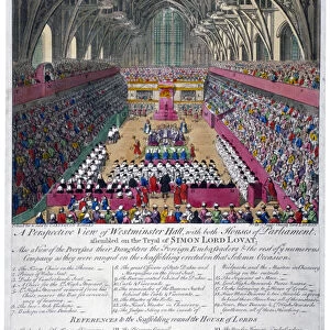
Old Map of the Ward of Cheap - About 1750, (1897). Map of part of the City of London, showing: Castle Court, Blossoms Inn, Hony Lane, Golden leg Court, Crown Court, Trump Alley, Dove Court, Poultry Compter, St Mildreds Church, Scalding Alley, Barg Yard and Crane Court, as well the Guildhall, Grocers Hall, and the church of St Mary-le-Bow. From Old and New London, Volume I, by Walter Thornbury. [Cassell and Company, Limited, London, Paris & Melbourne, 1897]
Heritage Images features heritage image collections
Media ID 18097567
© The Print Collector / Heritage-Images
Cassell Company Ltd Cheapside George Walter George Walter Thornbury Guildhall Old And New London Publisher Street Plan Thornbury Ward
FEATURES IN THESE COLLECTIONS
> Animals
> Birds
> Columbiformes
> Doves
> Black Dove
> Europe
> France
> Paris
> Maps
> Europe
> United Kingdom
> England
> Castles
> Europe
> United Kingdom
> England
> London
> Boroughs
> City of London
> Europe
> United Kingdom
> England
> London
> Towns
> Bow
> Europe
> United Kingdom
> England
> Maps
> Europe
> United Kingdom
> England
> Wells
EDITORS COMMENTS
This print showcases an "Old Map of the Ward of Cheap - About 1750" from a publication called Old and New London, Volume I by Walter Thornbury. Created in 1897, this map offers a fascinating glimpse into the bustling streets and landmarks of the City of London during the eighteenth century. The intricate details on this map highlight various notable locations such as Castle Court, Blossoms Inn, Hony Lane, Golden leg Court, Crown Court, Trump Alley, Dove Court, Poultry Compter, St Mildreds Church, Scalding Alley, Barg Yard and Crane Court. Additionally featured are prominent structures like Guildhall and Grocers Hall along with the iconic church of St Mary-le-Bow. With its monochrome aesthetic capturing every street plan and avenue meticulously drawn by an unknown creator from centuries ago; this print transports us back in time to witness the charm and vibrancy of olden-day London. The publisher Cassell & Company Ltd has done justice to preserving this historical gem for generations to come. Whether you're a history enthusiast or simply intrigued by British heritage; this remarkable image is sure to captivate your imagination. Let it transport you through time as you explore the winding lanes and busy roads that once shaped one of Europe's most influential cities.
MADE IN THE UK
Safe Shipping with 30 Day Money Back Guarantee
FREE PERSONALISATION*
We are proud to offer a range of customisation features including Personalised Captions, Color Filters and Picture Zoom Tools
SECURE PAYMENTS
We happily accept a wide range of payment options so you can pay for the things you need in the way that is most convenient for you
* Options may vary by product and licensing agreement. Zoomed Pictures can be adjusted in the Basket.