Home > Animals > Fishes > T > Trumpeter
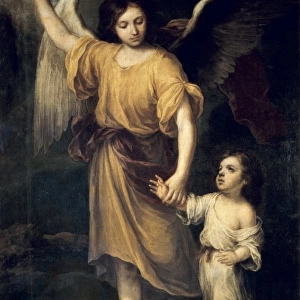
Map of the Republic of the Seven United Netherlands, 1677-1679. Creator: Nicolaes Visscher

![]()
Wall Art and Photo Gifts from Heritage Images
Map of the Republic of the Seven United Netherlands, 1677-1679. Creator: Nicolaes Visscher
Map of the Republic of the Seven United Netherlands, 1677-1679. At the bottom right, the Maas from Maastricht to Wessem. At the top left the title in a cartouche surrounded by putti, a trumpet-blowing angel, Mercury, Neptune and a woman with a globe. Above the inscription the angel holds a round shield with the coat of arms of the Netherlands. Scale in German and French miles. In the pedestal: Map from Maastricht to Wessem. Inscription
Heritage Images features heritage image collections
Media ID 36341208
© Heritage Art/Heritage Images
Amorini Angelic Armorial Crest Blazon Cartouche Cherubim Cherubs Coat Of Arms Crest God Of Sea God Of The Sea Heraldic Heraldry Mercury Neptune Nicolaes Visscher Poseidon Scale Sea God Shield Of Arms
FEATURES IN THESE COLLECTIONS
> Animals
> Fishes
> T
> Trumpeter
> Arts
> Art Movements
> Baroque
> Europe
> Belgium
> Related Images
> Europe
> Netherlands
> Maastricht
> Europe
> Netherlands
> Maps
> Europe
> Netherlands
> Posters
EDITORS COMMENTS
This stunning 17th century map print, titled "Map of the Republic of the Seven United Netherlands, 1677-1679," is a testament to the artistic and cartographic prowess of Nicolaes Visscher II. The intricately detailed work depicts the Netherlands during a period of great political and cultural significance, with the Seven United Provinces emerging as a major European power. The map is adorned with a vibrant cartouche at the top left, featuring a trumpet-blowing angel, Mercury, Neptune, and a woman holding a globe. Above the inscription, the angel proudly displays the coat of arms of the Netherlands on a round shield. The map's title is inscribed in elegant script, surrounded by cherubs, or putti, adding an air of divine approval. The map covers the region from Maastricht to Wessem, with the Maas River running along the bottom right. The intricate detail extends to the heraldic crests of various cities and towns, adding a rich layer of historical and cultural significance. The map is further enhanced by the use of color, with the Dutch provinces depicted in various hues, and the inclusion of a scale in German and French miles. This beautiful work of art, created during the Baroque era, is a testament to the artistic and cartographic achievements of the time. It is a reminder of the Netherlands' rich heritage and its role as a major European power during the 17th century. Today, it is a cherished piece of history, on display at the Rijksmuseum in Amsterdam, a fitting tribute to the artistic and historical significance of this magnificent map.
MADE IN THE UK
Safe Shipping with 30 Day Money Back Guarantee
FREE PERSONALISATION*
We are proud to offer a range of customisation features including Personalised Captions, Color Filters and Picture Zoom Tools
SECURE PAYMENTS
We happily accept a wide range of payment options so you can pay for the things you need in the way that is most convenient for you
* Options may vary by product and licensing agreement. Zoomed Pictures can be adjusted in the Basket.