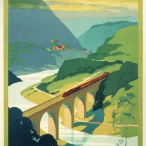
Home > Europe > United Kingdom > England > London > Sights > London Eye
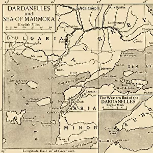
Poster Print : Map of the Dardanelles, First World War, 1915, (c1920). Creator: Unknown
. Creator: Unknown")


![]()
Poster Prints from Heritage Images
Map of the Dardanelles, First World War, 1915, (c1920). Creator: Unknown
Map of the Dardanelles, First World War, 1915, (c1920). Bird s-eye View of the Dardanelles from the Entrance to the Straits to the Narrows. From " The Great World War - A History" Volume III, edited by Frank A Mumby. [The Gresham Publishing Company Ltd, London, c1920]
Heritage Images features heritage image collections
Media ID 19175361
© The Print Collector/Heritage Images
Aerial View Dardanelles Dardanelles Campaign Frank Arthur Frank Arthur Mumby George Philip And Son George Philip And Son Ltd Gresham Publishing Co Ltd Gresham Publishing Company Hellespont Keystone Archives London Geographical Institute Mumby Mumby Frank Arthur Philip Strait The Great World War A History Theatre Of War Turkey 1st World War
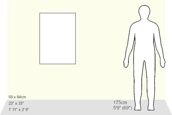
A1 (84.1 x 59.4cm) Poster Print
Step back in time with our vintage Map of the Dardanelles print from Media Storehouse. This historical poster, hailing from the First World War era around 1920, offers a captivating bird's-eye view of the strategic waterway from the entrance to the Straits to the Narrows. A fascinating addition to your collection, this rare and intriguing print, created by an unknown artist, provides a unique glimpse into the military history of the Dardanelles during wartime. Bring a piece of the past into your home or office with this beautifully preserved, vintage Map of the Dardanelles print from Media Storehouse.
A1 Poster (84.1 x 59.4cm, 33.1" x 23.4" inches) printed on 170gsm Satin Poster Paper. Securely packaged, rolled and inserted into a strong mailing tube and shipped tracked. Poster Prints are of comparable archival quality to our Photographic prints, they are simply printed on thinner Poster Paper. Whilst we only use Photographic Prints in our frames, you can frame Poster Prints if they are carefully supported to prevent sagging over time.
Poster prints are budget friendly enlarged prints in standard poster paper sizes (A0, A1, A2, A3 etc). Whilst poster paper is sometimes thinner and less durable than our other paper types, they are still ok for framing and should last many years. Our Archival Quality Photo Prints and Fine Art Paper Prints are printed on higher quality paper and the choice of which largely depends on your budget.
Estimated Image Size (if not cropped) is 59.4cm x 63.4cm (23.4" x 25")
Estimated Product Size is 59.4cm x 84.1cm (23.4" x 33.1")
These are individually made so all sizes are approximate
Artwork printed orientated as per the preview above, with portrait (vertical) orientation to match the source image.
FEATURES IN THESE COLLECTIONS
> Aerial Photography
> Related Images
> Asia
> Turkey
> Related Images
> Europe
> United Kingdom
> England
> London
> Art
> Theatre
> Europe
> United Kingdom
> England
> London
> Related Images
> Europe
> United Kingdom
> England
> London
> Sights
> London Eye
> Historic
> World War I and II
> World War I
> Historic
> World War I and II
> Maps and Charts
> Related Images
EDITORS COMMENTS
This print showcases a historically significant map of the Dardanelles during the First World War. Taken from "The Great World War - A History". Volume III, edited by Frank A Mumby, this aerial view provides a bird's-eye perspective of the strategic region. The Dardanelles campaign was a crucial theater of war in which various nations fought for control over this narrow strait connecting the Aegean Sea to the Sea of Marmara. The creator of this remarkable piece remains unknown, but their attention to detail is evident as they depict not only the geographical features but also the mountains surrounding this vital waterway. Published around 1920 by The Gresham Publishing Company Ltd in London, it serves as an invaluable historical artifact that sheds light on one of the most significant conflicts in modern history. With its intricate depiction and accurate representation, this map offers viewers a glimpse into an era defined by turmoil and conflict. It stands as a testament to human resilience and determination during times of war. Whether you are an avid historian or simply intrigued by world events, this print transports you back to a pivotal moment in time when nations clashed for supremacy amidst breathtaking natural landscapes.
MADE IN THE UK
Safe Shipping with 30 Day Money Back Guarantee
FREE PERSONALISATION*
We are proud to offer a range of customisation features including Personalised Captions, Color Filters and Picture Zoom Tools
SECURE PAYMENTS
We happily accept a wide range of payment options so you can pay for the things you need in the way that is most convenient for you
* Options may vary by product and licensing agreement. Zoomed Pictures can be adjusted in the Basket.