Home > Arts > Artists > M > Herman Moll
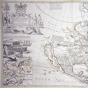
WEST INDIES MAP, 1715. Map of the West Indies and adjacent lands of the Carribean and Gulf of Mexico engraved by Herman Moll in 1715

![]()
Wall Art and Photo Gifts from Granger
WEST INDIES MAP, 1715. Map of the West Indies and adjacent lands of the Carribean and Gulf of Mexico engraved by Herman Moll in 1715
Granger holds millions of images spanning more than 25,000 years of world history, from before the Stone Age to the dawn of the Space Age
Media ID 7518015
1715 Caribbean Gulf Of Mexico Herman Island Moll West Indian
FEATURES IN THESE COLLECTIONS
> Arts
> Artists
> M
> Herman Moll
> Arts
> Landscape paintings
> Waterfall and river artworks
> River artworks
> North America
> Mexico
> Maps
EDITORS COMMENTS
This print showcases a remarkable piece of history - the "WEST INDIES MAP, 1715". Engraved by the talented Herman Moll, this map provides a fascinating glimpse into the West Indies and adjacent lands of the Caribbean and Gulf of Mexico during the early 18th century. The intricate details on this engraving transport us back in time to an era when exploration and colonization were at their peak. The map meticulously outlines various islands, rivers, and coastlines that played significant roles in shaping the region's rich cultural heritage. As we delve deeper into this artwork, we are reminded of the vastness and diversity present within these territories. From lush tropical landscapes to bustling port cities, each element depicted on this map tells its own story. Herman Moll's skillful craftsmanship is evident in every line etched onto this historical document. His attention to detail allows us to appreciate not only his artistic talent but also his dedication to accurately representing geographical features. Whether you are a history enthusiast or simply captivated by cartography, this print serves as both an educational tool and a beautiful work of art. It invites us to explore our past while igniting curiosity about how these lands have evolved over time. In collaboration with The Granger Collection, Granger Art on Demand presents this extraordinary piece for all those who seek inspiration from our world's diverse cultures and histories.
MADE IN THE UK
Safe Shipping with 30 Day Money Back Guarantee
FREE PERSONALISATION*
We are proud to offer a range of customisation features including Personalised Captions, Color Filters and Picture Zoom Tools
SECURE PAYMENTS
We happily accept a wide range of payment options so you can pay for the things you need in the way that is most convenient for you
* Options may vary by product and licensing agreement. Zoomed Pictures can be adjusted in the Basket.