Home > North America > United States of America > New York > New York > Maps
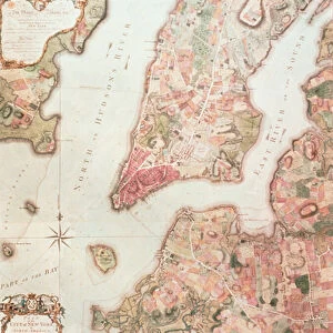
Plan of the City of New York, surveyed in 1767 by Bernard Ratzer, and inscribed by Ratzer to Henry Moore. The map also shows a small part of Long or Nassau Island, present day Brooklyn

![]()
Wall Art and Photo Gifts from Granger
Plan of the City of New York, surveyed in 1767 by Bernard Ratzer, and inscribed by Ratzer to Henry Moore. The map also shows a small part of Long or Nassau Island, present day Brooklyn
NEW YORK: MAP, 1767.
Plan of the City of New York, surveyed in 1767 by Bernard Ratzer, and inscribed by Ratzer to Henry Moore. The map also shows a small part of Long or Nassau Island, present day Brooklyn
Granger holds millions of images spanning more than 25,000 years of world history, from before the Stone Age to the dawn of the Space Age
Media ID 10411234
1767 Bernard Brooklyn Cartouche Colonial Downtown East River Long Island Lower Manhattan Manhattan Nassau New York City Plan United States
FEATURES IN THESE COLLECTIONS
> Abstract Art
> Sculpture
> Henry Moore
> Arts
> Artists
> M
> Henry Moore
> Arts
> Artists
> P
> those present
> Arts
> Landscape paintings
> Waterfall and river artworks
> River artworks
> Granger Art on Demand
> Plans and Diagrams
> North America
> United States of America
> New York
> New York
> Brooklyn
> Related Images
> North America
> United States of America
> New York
> New York
> Manhattan
> Related Images
> North America
> United States of America
> New York
> New York
> Maps
EDITORS COMMENTS
This print showcases the historic "Plan of the City of New York" surveyed in 1767 by Bernard Ratzer and inscribed to Henry Moore. The map provides a fascinating glimpse into the early days of America's most iconic city, depicting both Manhattan and a small part of Long Island, known as present-day Brooklyn. With intricate details and precision, Ratzer's map highlights the layout and development of colonial New York City. From its bustling downtown area along the East River to the serene beauty of Lower Manhattan, every street and landmark is meticulously depicted. The cartouche adds an elegant touch to this historical artifact, symbolizing its significance in documenting America's past. As we gaze upon this remarkable piece from Granger Art on Demand's Carousel Collection, we are transported back in time to witness how New York City evolved from humble beginnings into one of the world's greatest metropolises. It serves as a reminder that beneath today's towering skyscrapers lies a rich history rooted in exploration, trade, and cultural diversity. Whether you're an avid historian or simply intrigued by New York City's heritage, this print offers a unique opportunity to connect with our nation's past. Let it serve as a conversation starter or an inspiring decoration for your home or office space – reminding us all that even amidst constant change, traces of history can still be found if we take the time to look closely enough.
MADE IN THE UK
Safe Shipping with 30 Day Money Back Guarantee
FREE PERSONALISATION*
We are proud to offer a range of customisation features including Personalised Captions, Color Filters and Picture Zoom Tools
FREE COLORIZATION SERVICE
You can choose advanced AI Colorization for this picture at no extra charge!
SECURE PAYMENTS
We happily accept a wide range of payment options so you can pay for the things you need in the way that is most convenient for you
* Options may vary by product and licensing agreement. Zoomed Pictures can be adjusted in the Basket.