Home > Arts > Landscape paintings > Waterfall and river artworks > River artworks
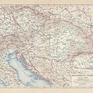
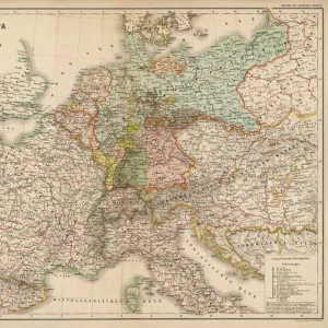
SLAVIC POPULATION MAP. Map showing the distribution of the Slav peoples in the 10th century A

![]()
Wall Art and Photo Gifts from Granger
SLAVIC POPULATION MAP. Map showing the distribution of the Slav peoples in the 10th century A
SLAVIC POPULATION MAP.
Map showing the distribution of the Slav peoples in the 10th century A.D
Granger holds millions of images spanning more than 25,000 years of world history, from before the Stone Age to the dawn of the Space Age
Media ID 12321100
10th Century Adriatic Austria Balkan Baltic Black Sea Czechoslovakia Dark Ages Hungary Norway Peninsula Poland Population Slavic Sweden Caspian Sea
FEATURES IN THESE COLLECTIONS
> Arts
> Landscape paintings
> Waterfall and river artworks
> River artworks
> Granger Art on Demand
> Maps
SLAVIC POPULATION MAP - Tracing the Footprints of a Rich Cultural Legacy
EDITORS COMMENTS
. This photo print, titled "SLAVIC POPULATION MAP" offers a mesmerizing glimpse into the distribution of Slav peoples during the 10th century A. D. The map showcases an intricate web of territories across Europe, spanning from the Adriatic to Austria and from the Baltic to the Black Sea. In this visual representation, one can discern how Slavic communities flourished along rivers and peninsulas, leaving their indelible mark on history. From Czechoslovakia to Hungary, Poland to Sweden, these lands were once inhabited by vibrant cultures that thrived amidst medieval times and dark ages. The map not only serves as a testament to the vastness of Slavic influence but also highlights their interconnectedness with neighboring regions. It reveals how trade routes crisscrossed through Caspian Sea ports and connected diverse populations across borders. As we gaze upon this historical artifact, it is impossible not to marvel at the resilience and tenacity of these ancient societies. Their rich cultural heritage continues to shape our understanding of Eastern European traditions today. This print by Granger Art on Demand invites us on a journey through time – an exploration that deepens our appreciation for diversity and reminds us of humanity's ability to adapt and evolve throughout centuries.
MADE IN THE UK
Safe Shipping with 30 Day Money Back Guarantee
FREE PERSONALISATION*
We are proud to offer a range of customisation features including Personalised Captions, Color Filters and Picture Zoom Tools
SECURE PAYMENTS
We happily accept a wide range of payment options so you can pay for the things you need in the way that is most convenient for you
* Options may vary by product and licensing agreement. Zoomed Pictures can be adjusted in the Basket.