Home > Arts > Landscape paintings > Waterfall and river artworks > River artworks
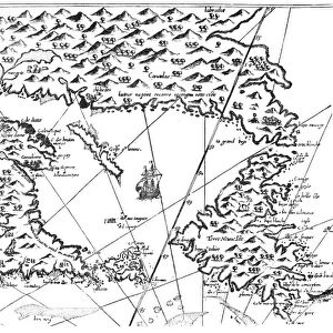
NEW FRANCE, 1719. French engraved map with inset plan and view of Quebec and

![]()
Wall Art and Photo Gifts from Granger
NEW FRANCE, 1719. French engraved map with inset plan and view of Quebec and
NEW FRANCE, 1719. French engraved map with inset plan and view of Quebec and, at the top, an enlargement of the area from the Mississippi River to Pensacola Bay
Granger holds millions of images spanning more than 25,000 years of world history, from before the Stone Age to the dawn of the Space Age
Media ID 6622201
1719 Colony Mississippi Mississippi River New France Quebec
FEATURES IN THESE COLLECTIONS
> Arts
> Landscape paintings
> Waterfall and river artworks
> River artworks
> Granger Art on Demand
> Maps
EDITORS COMMENTS
This stunning print showcases a piece of history frozen in time - "NEW FRANCE, 1719". The French engraved map takes us back to the early days of colonization, offering a glimpse into the vast territory known as New France. With intricate details and precision, this map provides an invaluable resource for understanding the geography and layout of this once-thriving colony. The inset plan and view of Quebec brings forth a sense of nostalgia as we witness the city's charm during its formative years. From its strategic location along the St. Lawrence River to its impressive fortifications, Quebec stands proudly as a testament to French influence in North America. At the top of this remarkable print lies an enlargement capturing an area stretching from the mighty Mississippi River to Pensacola Bay. This expansion allows us to explore further into New France's southern territories, revealing untamed landscapes and potential for future growth. With every line meticulously etched by skilled hands, this French engraved map serves not only as a historical artifact but also as a work of art. Its rich colors and intricate illustrations transport us back to an era when exploration was at its peak and new frontiers were being discovered. Thanks to The Granger Collection's dedication to preserving our past through art on demand, we can now bring home a piece of history with this photo print. Whether you are an avid historian or simply appreciate beautiful craftsmanship, "NEW FRANCE, 1719" is sure to captivate your imagination and spark conversations about our shared heritage
MADE IN THE UK
Safe Shipping with 30 Day Money Back Guarantee
FREE PERSONALISATION*
We are proud to offer a range of customisation features including Personalised Captions, Color Filters and Picture Zoom Tools
SECURE PAYMENTS
We happily accept a wide range of payment options so you can pay for the things you need in the way that is most convenient for you
* Options may vary by product and licensing agreement. Zoomed Pictures can be adjusted in the Basket.