Home > Arts > Artists > S > John Seller
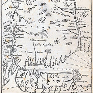
MAP: EAST INDIES, 1670. Chart of the East Indies (oriented with north at the left) by John Seller
 by John Seller")
![]()
Wall Art and Photo Gifts from Granger
MAP: EAST INDIES, 1670. Chart of the East Indies (oriented with north at the left) by John Seller
MAP: EAST INDIES, 1670. Chart of the East Indies (oriented with north at the left) by John Seller, 1670
Granger holds millions of images spanning more than 25,000 years of world history, from before the Stone Age to the dawn of the Space Age
Media ID 6617173
1670 Age Of Discovery East Indian Island New World Portolan Chart East Indies
FEATURES IN THESE COLLECTIONS
> Arts
> Artists
> S
> John Seller
> Granger Art on Demand
> Maps
> Maps and Charts
> World
EDITORS COMMENTS
This print showcases a historical treasure, the "MAP: EAST INDIES, 1670". Created by the talented cartographer John Seller during the Age of Discovery, this chart of the East Indies takes us on a journey back in time. With its unique orientation placing north at the left, it offers a fresh perspective on navigation and exploration. The intricate details of this map are truly awe-inspiring. Every island is meticulously depicted with precision and accuracy, allowing viewers to immerse themselves in the rich geography of this region. As we gaze upon this masterpiece, we can almost feel ourselves transported to an era when intrepid sailors braved uncharted waters in search of new worlds. The significance of this map extends beyond its aesthetic appeal. It serves as a testament to the spirit of adventure that defined an entire era. The East Indies were coveted for their exotic spices and valuable trade routes, making them highly sought after by European powers at that time. As we admire this piece from The Granger Collection's archives, let us appreciate not only its artistic beauty but also its historical importance. This portolan chart represents more than just lines on paper; it symbolizes humanity's insatiable thirst for knowledge and discovery. Whether you are an avid history enthusiast or simply captivated by stunning artwork, "MAP: EAST INDIES, 1670" is sure to leave you spellbound with its timeless allure.
MADE IN THE UK
Safe Shipping with 30 Day Money Back Guarantee
FREE PERSONALISATION*
We are proud to offer a range of customisation features including Personalised Captions, Color Filters and Picture Zoom Tools
SECURE PAYMENTS
We happily accept a wide range of payment options so you can pay for the things you need in the way that is most convenient for you
* Options may vary by product and licensing agreement. Zoomed Pictures can be adjusted in the Basket.