Home > Arts > Landscape paintings > Waterfall and river artworks > River artworks
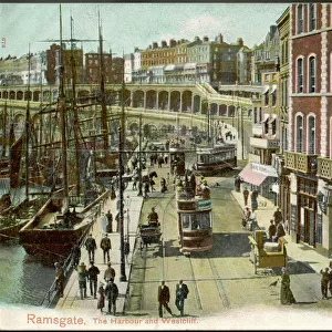
MAP: AFRICA, 19th CENTURY. A late 19th century map of Africa with an insert showing the Suez Canal

![]()
Wall Art and Photo Gifts from Granger
MAP: AFRICA, 19th CENTURY. A late 19th century map of Africa with an insert showing the Suez Canal
Granger holds millions of images spanning more than 25,000 years of world history, from before the Stone Age to the dawn of the Space Age
Media ID 6617389
Africa African Canal Continent Suez Canal
FEATURES IN THESE COLLECTIONS
> Africa
> Related Images
> Arts
> Landscape paintings
> Waterfall and river artworks
> River artworks
> Granger Art on Demand
> Maps
EDITORS COMMENTS
This print from Granger Art on Demand takes us back to the late 19th century, offering a glimpse into the intricate details of an African map. The map itself showcases the vastness and diversity of the continent, with its rich tapestry of nations, rivers, and landscapes. Africa's unique shape is beautifully depicted in this vintage piece, reminding us of its significance as one of Earth's most awe-inspiring continents. What makes this particular print even more intriguing is the inclusion of an insert showcasing the iconic Suez Canal. This man-made marvel connects two great bodies of water - the Mediterranean Sea and the Red Sea - providing a vital trade route between Europe and Asia. Its presence on this historical map serves as a testament to human ingenuity and our ability to reshape nature for our benefit. As we gaze upon this remarkable artwork by The Granger Collection, we are transported back in time to an era when exploration was at its peak. It reminds us that maps not only serve as navigational tools but also encapsulate stories of discovery, conquests, and cultural exchange. Whether you're a history enthusiast or simply appreciate art that tells tales from bygone eras, this print offers a fascinating window into Africa's past while highlighting one of humanity's greatest engineering achievements – all captured through The Granger Collection's meticulous attention to detail.
MADE IN THE UK
Safe Shipping with 30 Day Money Back Guarantee
FREE PERSONALISATION*
We are proud to offer a range of customisation features including Personalised Captions, Color Filters and Picture Zoom Tools
SECURE PAYMENTS
We happily accept a wide range of payment options so you can pay for the things you need in the way that is most convenient for you
* Options may vary by product and licensing agreement. Zoomed Pictures can be adjusted in the Basket.