Home > Arts > Artists > O > Abraham Ortelius
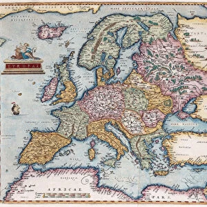
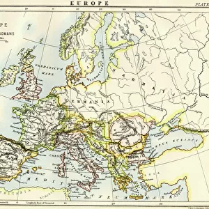
MAP OF THE ROMAN EMPIRE. From the 1595 atlas, Theatrum Orbis Terrarum

![]()
Wall Art and Photo Gifts from Granger
MAP OF THE ROMAN EMPIRE. From the 1595 atlas, Theatrum Orbis Terrarum
MAP OF THE ROMAN EMPIRE. From the 1595 atlas, Theatrum Orbis Terrarum, by Abraham Oertel, also known as Ortelius, featuring portraits of Roma, deity of ancient Rome, and Romulus, the citys legendary founder
Granger holds millions of images spanning more than 25,000 years of world history, from before the Stone Age to the dawn of the Space Age
Media ID 6616295
1595 Abraham Dictator Empire Ortelius Roma Roman Roman Empire Romulus Theatrum Orbis Terrarum Oertel
FEATURES IN THESE COLLECTIONS
> Arts
> Artists
> O
> Abraham Ortelius
> Arts
> Landscape paintings
> Waterfall and river artworks
> River artworks
> Europe
> Italy
> Lazio
> Rome
> Granger Art on Demand
> Maps
> Maps and Charts
> Abraham Ortelius
> Maps and Charts
> Early Maps
EDITORS COMMENTS
This print showcases a remarkable piece of history - the Map of the Roman Empire from the renowned 1595 atlas, Theatrum Orbis Terrarum by Abraham Oertel, also known as Ortelius. This exquisite map takes us back to ancient times, providing a visual representation of the vast and powerful Roman Empire. The intricate details on this print are truly awe-inspiring. As we explore its surface, we encounter portraits of two significant figures - Roma, the deity symbolizing ancient Rome's glory and power, and Romulus, the legendary founder of this magnificent city. Their presence adds an air of mystique and reverence to this historical artifact. With its Renaissance-era design elements and meticulous craftsmanship, this map transports us to an era when empires were built along rivers that served as lifelines for trade and conquest. It offers a glimpse into how territories were delineated during that time period while highlighting key cities within the Roman Empire. As we delve deeper into this artwork created by Ortelius/Oertel – both names associated with excellence in cartography – it becomes evident why it is considered such a prized possession. Its significance lies not only in its historical value but also in its ability to ignite our imagination and curiosity about one of civilization's most influential empires. This Granger Collection print allows us to appreciate artistry combined with historical accuracy at its finest. It serves as a reminder that even centuries later, these remnants from our past continue to captivate audiences worldwide without
MADE IN THE UK
Safe Shipping with 30 Day Money Back Guarantee
FREE PERSONALISATION*
We are proud to offer a range of customisation features including Personalised Captions, Color Filters and Picture Zoom Tools
SECURE PAYMENTS
We happily accept a wide range of payment options so you can pay for the things you need in the way that is most convenient for you
* Options may vary by product and licensing agreement. Zoomed Pictures can be adjusted in the Basket.