Home > Arts > Artists > H > Jodocus Hondius
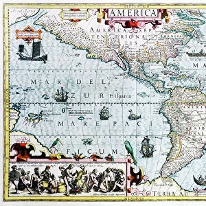
MAP: STRAIT OF MAGELLAN, 1611. An early depiction of the Strait of Magellan at the

![]()
Wall Art and Photo Gifts from Granger
MAP: STRAIT OF MAGELLAN, 1611. An early depiction of the Strait of Magellan at the
MAP: STRAIT OF MAGELLAN, 1611. An early depiction of the Strait of Magellan at the tip of South America, oriented with south to north with Tierra del Fuego at the bottom of the page. Map by Jodocus Hondius, 1611
Granger holds millions of images spanning more than 25,000 years of world history, from before the Stone Age to the dawn of the Space Age
Media ID 13642996
1611 Argentina Cartography Chile Hondius South America Strait Strait Of Magellan Tierra Del Fuego
FEATURES IN THESE COLLECTIONS
> Arts
> Artists
> H
> Jodocus Hondius
> Maps and Charts
> Early Maps
> South America
> Argentina
> Maps
> South America
> Chile
> Maps
EDITORS COMMENTS
This print showcases an early depiction of the Strait of Magellan, dating back to 1611. The map, created by Jodocus Hondius, offers a fascinating glimpse into the geographical knowledge and cartography techniques of that era. The Strait of Magellan is prominently featured at the tip of South America in this stunning artwork. The map is oriented with south to north, presenting Tierra del Fuego at the bottom of the page. This unique perspective allows viewers to immerse themselves in the historical significance and natural beauty associated with this iconic region. As we delve into this intricate piece, we are transported back in time to witness how explorers navigated these treacherous waters centuries ago. The attention to detail and precision evident in Hondius' work highlights his mastery as a cartographer. With Argentina and Chile flanking either side of the strait, it becomes apparent just how strategically important this passage was for trade routes between Europe and Asia during that period. This extraordinary print from Granger Art on Demand not only serves as a visual delight but also invites us to reflect upon our ever-evolving understanding of our planet's geography. It reminds us that exploration has always been an integral part of human history - pushing boundaries, expanding horizons, and unraveling mysteries one map at a time.
MADE IN THE UK
Safe Shipping with 30 Day Money Back Guarantee
FREE PERSONALISATION*
We are proud to offer a range of customisation features including Personalised Captions, Color Filters and Picture Zoom Tools
SECURE PAYMENTS
We happily accept a wide range of payment options so you can pay for the things you need in the way that is most convenient for you
* Options may vary by product and licensing agreement. Zoomed Pictures can be adjusted in the Basket.