Home > Asia > Georgia > Maps
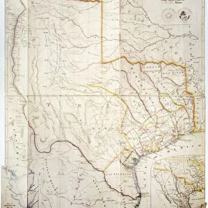
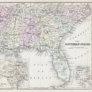
MAP: RAILROAD, 1864. Railway and county map of the Southern States; embracing the States of N. Carolina, S. Carolina, Georgia, Alabama, Florida, Mississippi, Louisiana, Arkansas, and Tennessee... Engraving by Joseph Beuther, 1864

![]()
Wall Art and Photo Gifts from Granger
MAP: RAILROAD, 1864. Railway and county map of the Southern States; embracing the States of N. Carolina, S. Carolina, Georgia, Alabama, Florida, Mississippi, Louisiana, Arkansas, and Tennessee... Engraving by Joseph Beuther, 1864
Granger holds millions of images spanning more than 25,000 years of world history, from before the Stone Age to the dawn of the Space Age
Media ID 7560183
1864 Alabama Arkansas County Florida Georgia Joseph Louisiana Mississippi North Carolina Rail Road Railway Road South Carolina Station Tennessee Texas
FEATURES IN THESE COLLECTIONS
> South America
> Related Images
EDITORS COMMENTS
This print titled "MAP: RAILROAD, 1864" takes us back to a significant moment in American history. Engraved by Joseph Beuther in 1864, this railway and county map showcases the Southern States of North Carolina, South Carolina, Georgia, Alabama, Florida, Mississippi, Louisiana, Arkansas, and Tennessee. The intricate details of the map highlight the extensive rail network that connected these states during that era. It serves as a testament to the importance of railways in shaping transportation and commerce across the region. The carefully etched lines depict various routes and stations along with counties within each state. As we gaze upon this historical artifact from over a century ago, we can't help but imagine how different life must have been for those who relied on these railroads for travel and trade. This map provides a glimpse into an interconnected world where people could traverse vast distances with relative ease compared to previous modes of transportation. Joseph Beuther's engraving skills bring out every minute detail on this piece of art – from the curves of rivers to the borders between states. It is truly remarkable how such craftsmanship has preserved this snapshot of Southern America's past. Granger Art on Demand presents us with yet another treasure that allows us to appreciate our rich history through visual storytelling. Let this mesmerizing print transport you back in time as you explore the intricacies woven into every inch of this railway and county map from 1864.
MADE IN THE UK
Safe Shipping with 30 Day Money Back Guarantee
FREE PERSONALISATION*
We are proud to offer a range of customisation features including Personalised Captions, Color Filters and Picture Zoom Tools
SECURE PAYMENTS
We happily accept a wide range of payment options so you can pay for the things you need in the way that is most convenient for you
* Options may vary by product and licensing agreement. Zoomed Pictures can be adjusted in the Basket.