Home > Europe > United Kingdom > England > London > River Thames
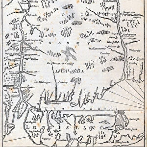
MAP: CONNECTICUT, 1661. Map of Connecticut in 1661, from John Sellers contemporary Map of New England. Line engraving, 19th century

![]()
Wall Art and Photo Gifts from Granger
MAP: CONNECTICUT, 1661. Map of Connecticut in 1661, from John Sellers contemporary Map of New England. Line engraving, 19th century
Granger holds millions of images spanning more than 25,000 years of world history, from before the Stone Age to the dawn of the Space Age
Media ID 7558535
1661 Colonial Connecticut Frontier Hudson River Mohican Puritan Settlement Thames River Vendor
FEATURES IN THESE COLLECTIONS
> Arts
> Artists
> S
> John Seller
> Arts
> Contemporary art
> Arts
> Landscape paintings
> Waterfall and river artworks
> River artworks
> Arts
> Pop art
> Contemporary art
> Contemporary art gallery
> Europe
> United Kingdom
> England
> London
> River Thames
> Europe
> United Kingdom
> England
> Maps
> Europe
> United Kingdom
> England
> Rivers
EDITORS COMMENTS
This 19th-century line engraving takes us back in time to the year 1661, showcasing a detailed map of Connecticut. Created by John Sellers as part of his contemporary Map of New England, this print offers a glimpse into the early colonial period in America. The map depicts an intricate network of settlements and landmarks that were crucial for both English settlers and Native American tribes such as the Mohican. It showcases the vast frontier stretching from the Hudson River to the Thames River, highlighting key areas where Puritan communities thrived alongside indigenous populations. Through its meticulous engravings, this historical artifact transports us to a pivotal moment in American history when cultures collided and new alliances formed. The presence of an Indian vendor on the map emphasizes the complex interactions between different groups during this era. As we examine each detail within this print, we are reminded of how maps not only serve as navigational tools but also hold immense cultural significance. This particular piece provides valuable insights into early settlement patterns and territorial claims while capturing a snapshot of life in colonial Connecticut. With its rich historical context and artistic craftsmanship, this Granger Collection print is sure to captivate anyone with an interest in American history or cartography.
MADE IN THE UK
Safe Shipping with 30 Day Money Back Guarantee
FREE PERSONALISATION*
We are proud to offer a range of customisation features including Personalised Captions, Color Filters and Picture Zoom Tools
SECURE PAYMENTS
We happily accept a wide range of payment options so you can pay for the things you need in the way that is most convenient for you
* Options may vary by product and licensing agreement. Zoomed Pictures can be adjusted in the Basket.