Home > North America > United States of America > New York > New York > Maps
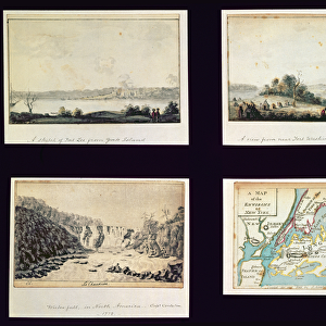
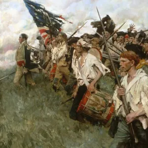
NEW YORK: ARMIES, 1776. Plan of the positions of the British and American armies in New York, Long Island and Staten Island, 27 August 1776. Wood engraving, American, 1852

![]()
Wall Art and Photo Gifts from Granger
NEW YORK: ARMIES, 1776. Plan of the positions of the British and American armies in New York, Long Island and Staten Island, 27 August 1776. Wood engraving, American, 1852
NEW YORK: ARMIES, 1776.
Plan of the positions of the British and American armies in New York, Long Island and Staten Island, 27 August 1776. Wood engraving, American, 1852
Granger holds millions of images spanning more than 25,000 years of world history, from before the Stone Age to the dawn of the Space Age
Media ID 7559883
1776 American Revolution Army Attack British Brooklyn Invasion Long Island Manhattan Navy New York Plan Position Queen Queens Revolutionary War Staten Island War Ship
FEATURES IN THESE COLLECTIONS
> Granger Art on Demand
> American Revolution
> North America
> United States of America
> New York
> New York
> Brooklyn
> Related Images
> North America
> United States of America
> New York
> New York
> Manhattan
> Related Images
> North America
> United States of America
> New York
> New York
> Maps
> North America
> United States of America
> New York
> New York
> Queens
> Related Images
> North America
> United States of America
> New York
> New York
> Staten Island
> Related Images
EDITORS COMMENTS
This print titled "NEW YORK: ARMIES, 1776" takes us back to a significant moment in American history. The wood engraving, created by an American artist in 1852, depicts the strategic positions of the British and American armies on August 27th, 1776. The image showcases the intensity of the Revolutionary War as it unfolded in New York City and its surrounding areas. With great attention to detail, this map-like illustration highlights key locations such as Manhattan, Long Island, Staten Island, and Brooklyn. It provides a visual representation of the battlefield where these two formidable forces clashed. Intriguingly, one can observe warships dotting the waters around these islands - a reminder of naval power playing a crucial role during this time. The presence of both American and British flags symbolizes their respective allegiances and determination to secure victory. As we delve into this historical snapshot from Granger Art on Demand's Carousel Collection, we are transported back to an era when America fought for independence against colonial rule. This print serves as a testament to the bravery and sacrifice exhibited by those who fought on both sides during this pivotal chapter known as the American Revolution.
MADE IN THE UK
Safe Shipping with 30 Day Money Back Guarantee
FREE PERSONALISATION*
We are proud to offer a range of customisation features including Personalised Captions, Color Filters and Picture Zoom Tools
SECURE PAYMENTS
We happily accept a wide range of payment options so you can pay for the things you need in the way that is most convenient for you
* Options may vary by product and licensing agreement. Zoomed Pictures can be adjusted in the Basket.