Home > Arts > Pop art > Contemporary art > Contemporary art gallery
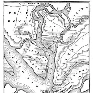
JOHNSTOWN FLOOD, 1889. Map of the area covered by the floods on 31 May 1889

![]()
Wall Art and Photo Gifts from Granger
JOHNSTOWN FLOOD, 1889. Map of the area covered by the floods on 31 May 1889
JOHNSTOWN FLOOD, 1889.
Map of the area covered by the floods on 31 May 1889. Line engraving from a contemporary American newspaper
Granger holds millions of images spanning more than 25,000 years of world history, from before the Stone Age to the dawn of the Space Age
Media ID 12225894
1889 Flood Johnstown Northeast United States
FEATURES IN THESE COLLECTIONS
> Arts
> Contemporary art
> Arts
> Landscape paintings
> Waterfall and river artworks
> River artworks
> Arts
> Pop art
> Contemporary art
> Contemporary art gallery
> Granger Art on Demand
> American History
EDITORS COMMENTS
This print titled "JOHNSTOWN FLOOD, 1889. Map of the area covered by the floods on 31 May 1889" takes us back in time to a tragic event that forever changed the landscape of Johnstown, Pennsylvania. The image showcases a detailed line engraving from a contemporary American newspaper, offering us a glimpse into the devastating aftermath of one of America's deadliest natural disasters. In this hauntingly beautiful piece, we see an intricately drawn map depicting the extent of destruction caused by the flood that occurred on May 31st, 1889. The floodwaters have engulfed vast portions of land in North and Northeast Johnstown, leaving behind only remnants of what was once thriving communities. The artist's attention to detail allows us to trace the path of devastation along the river as it snakes its way through this unfortunate town. Each stroke captures both the power and tragedy unleashed upon this unsuspecting community. As we gaze at this historical artifact frozen in time, we are reminded not only of nature's unforgiving force but also of human resilience and determination to rebuild after such immense loss. This photograph serves as a poignant reminder that even amidst darkness and despair, hope can emerge from ruins. "JOHNSTOWN FLOOD, 1889" is more than just an artistic representation; it is a testament to our ability to overcome adversity and find strength in unity—a timeless tribute to those who lost their lives or were forever impacted by this catastrophic
MADE IN THE UK
Safe Shipping with 30 Day Money Back Guarantee
FREE PERSONALISATION*
We are proud to offer a range of customisation features including Personalised Captions, Color Filters and Picture Zoom Tools
SECURE PAYMENTS
We happily accept a wide range of payment options so you can pay for the things you need in the way that is most convenient for you
* Options may vary by product and licensing agreement. Zoomed Pictures can be adjusted in the Basket.