
Trade Winds Collection
Discover the intriguing world of Trade Winds, the global atmospheric phenomenon that has shaped maritime history and commerce since ancient times


All Professionally Made to Order for Quick Shipping
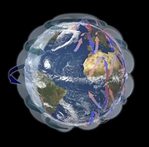
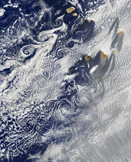
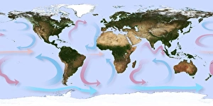
Discover the intriguing world of Trade Winds, the global atmospheric phenomenon that has shaped maritime history and commerce since ancient times. This satellite-based diagram (C016 / 3731) illustrates the prevailing wind patterns, with the Trade Winds dominating the equatorial regions. The historic map "A New and Correct Map of the World" (1770-97) depicts the Trade Winds' influence on sailing routes, particularly in the Atlantic. Southern India and Ceylon's map (Atlas de Toutes les Parties Connues du Globe) highlights the monsoon winds' interaction with the Trade Winds. Herman Moll's map of the West Indies (1720) offers a detailed look at the Trade Winds' impact on ocean currents. Global wind patterns, as shown in this artwork, reveal the Trade Winds' consistent direction from the northeast in the Northern Hemisphere and the southeast in the Southern Hemisphere. The Von Karman vortices near the Cape Verde islands are a notable feature of these winds, while the Chart of the Atlantic Ocean (1802 C015 / 5215) demonstrates the Trade Winds' role in shaping ocean currents. QuikSCAT radar images reveal the Atlantic storms that form due to the interaction between the Trade Winds and the warm waters, adding another layer of complexity to this fascinating meteorological phenomenon.