
Springdale Collection
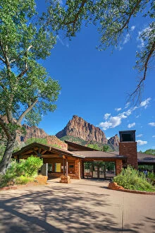
"Springdale: A Scenic Oasis in the Heart of Nature's Masterpieces" Nestled amidst the breathtaking landscapes of Zion National Park in Utah


All Professionally Made to Order for Quick Shipping
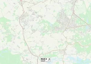
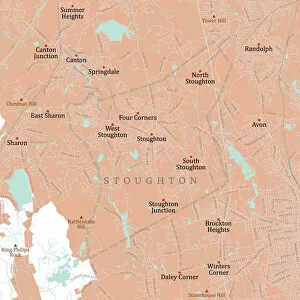
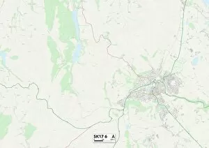
"Springdale: A Scenic Oasis in the Heart of Nature's Masterpieces" Nestled amidst the breathtaking landscapes of Zion National Park in Utah, a hidden gem that captivates visitors with its awe-inspiring beauty. As fall paints a vibrant tapestry across the horizon, the reflections of trees adorned in rich autumn hues create an enchanting spectacle. The cliffs of Zion stand tall and majestic, guarding this natural wonderland like ancient sentinels. The Subway, a renowned hiking trail within the park, beckons adventurers to explore its mystical depths and discover hidden treasures along its winding path. Beyond Utah's borders lie other destinations waiting to be explored. Norfolk County in Massachusetts unveils Stoughton Vector Road Map, leading travelers on scenic routes through charming towns and picturesque countryside. Canton Vector Road Map reveals another facet of this region's allure, where history merges seamlessly with modernity. Venturing further east into Hampden County brings you to Chicopee Vector Road Map - a gateway to an array of outdoor adventures and cultural experiences. Connecticut's Fairfield County boasts Darien Vector Road Map as well as Stamford and Norwalk Vector Road Maps; these guides open doors to coastal delights and thriving communities brimming with charm. Across the Atlantic Ocean lies Derbyshire Dales SK17 6 Map - an English countryside haven dotted with quaint villages nestled amid rolling hillsides. Northumberland TD15 2 Map unravels centuries-old castles standing proudly against dramatic coastlines while Wokingham RG40 4 Map offers glimpses into idyllic market towns surrounded by lush greenery. Amidst all these diverse landscapes lies Springdale – a place where nature's wonders converge from different corners of the world. Whether it be exploring Zion National Park or embarking on road trips through New England or even venturing across oceans for European escapades – Springdale serves as a starting point for unforgettable journeys filled with awe-inspiring sights and unforgettable memories.