
Satellite Program Collection
Exploring the World from Above: A Glimpse into the Satellite Program Satellites have revolutionized our understanding of Earth


All Professionally Made to Order for Quick Shipping
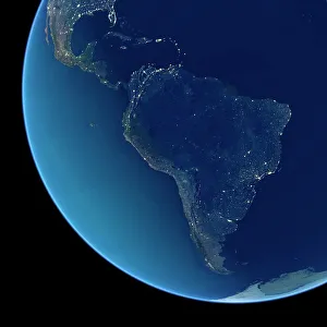
Exploring the World from Above: A Glimpse into the Satellite Program Satellites have revolutionized our understanding of Earth, providing breathtaking images that showcase our planet's beauty and diversity. In this captivating satellite program, we embark on a visual journey across continents, witnessing stunning landscapes illuminated by city lights at night. As darkness falls over Europe, satellite images reveal a mesmerizing tapestry of glowing cities and interconnected highways. The continent transforms into an intricate web of vibrant energy as millions go about their lives under shimmering constellations. Venturing further westward, South America emerges in all its nocturnal splendor. From the Amazon rainforest to bustling metropolises like Rio de Janeiro and Buenos Aires, these satellite images capture the pulsating heartbeat of a continent that never sleeps. Crossing over to North America, we witness vast urban expanses stretching from coast to coast. Iconic landmarks such as New York City's skyline or Los Angeles' sprawling streets become beacons of light against the dark canvas below—a testament to human ingenuity and ambition. The African continent reveals its own unique charm when illuminated by artificial lights after sunset. Satellite imagery showcases both ancient wonders like Egypt's pyramids and modern cities like Johannesburg or Nairobi—each with its distinct cultural heritage shining through even in darkness. Zooming out for a broader perspective, satellite cameras capture breathtaking shots of Earth entirely bathed in twinkling lights during nighttime. This awe-inspiring view reminds us how interconnected our world truly is—an intricate mosaic where every corner holds stories waiting to be discovered. Heading southwards towards Australia unveils another remarkable sight—the land Down Under transformed into an ethereal dreamscape under starry skies. From Sydney's iconic Opera House to Uluru-Kata Tjuta National Park's sacred rock formations—these satellite images encapsulate Australia's diverse landscapes aglow with life after dusk settles in.