mail_outline sales@mediastorehouse.com
Framed Print
Antique Framed Print
Premium Framed Print
Canvas Print
Metal Print
Photographic Print
Poster Print
Fine Art Print
Mounted Print
Glass Frame
Acrylic Blox
Jigsaw Puzzle
Tote Bag
Photo Mug
Greetings Card
Postcard
Cushion
Mouse Mat
Glass Place Mat
Glass Coaster
General Map of Poltava Province: Showing Postal and Major Roads, Stations and... 1821General Map of Poltava Province: Showing Postal and Major Roads, Stations and the Distance in Versts between Them, 1821. This 1821 map of Poltava Provinceis from a larger work
Poltava Province, 1856. Creator: UnknownPoltava Province, 1856. This card is one of a souvenir set of 82 illustrated cards-one for each province of the Russian Empire as it existed in 1856
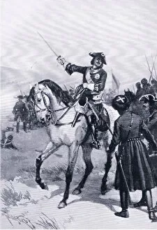
Peter the Great at the battle of Pultowa, illustration from Landmarks in European History3787867 Peter the Great at the battle of Pultowa, illustration from Landmarks in European History published by Gresham Publishing Co, c.1920 (litho) by Thulstrup
Peter I at Pultowa (engraving)655767 Peter I at Pultowa (engraving) by English School, (19th century); Private Collection; (add.info.: Peter I at Pultowa)
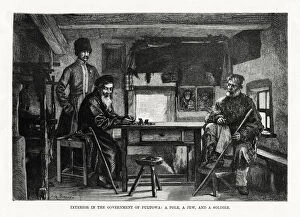
Interior in the Government of Pultowa, central Ukraine, 1879. Inhabitants of Poltava: a Pole, a Jew, and a soldier
The Battle of Pottava, 1709 (engraving) (b / w photo)XJF280546 The Battle of Pottava, 1709 (engraving) (b/w photo) by Picart, Bernard (1673-1733); Private Collection; (add.info.: Great Northern War (1700-21); ); French, out of copyright
Russian victory at PultowaThe captured standards after the battle of Poltava(also spelt Pultowa)
Battle of Poltava 1709BATTLE OF POLTAVA Peter the Great defeats Charles XII of Sweden at Poltava (Pultowa)