mail_outline sales@mediastorehouse.com
Framed Print
Antique Framed Print
Premium Framed Print
Canvas Print
Metal Print
Photographic Print
Poster Print
Fine Art Print
Mounted Print
Glass Frame
Acrylic Blox
Jigsaw Puzzle
Tote Bag
Photo Mug
Greetings Card
Postcard
Cushion
Mouse Mat
Glass Place Mat
Glass Coaster
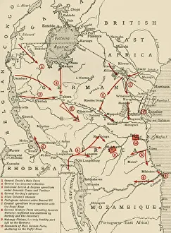
Colonial possessions in East Africa during the First World War, c1916, (c1920). Creator: UnknownColonial possessions in East Africa during the First World War, c1916, (c1920). Map showing German East Africa, British East Africa, the Belgian Congo, Rhodesia, Uganda
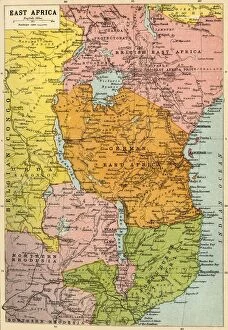
Map of East Africa, First World War, (c1920). Creator: John Bartholomew & SonMap of East Africa, First World War, (c1920). Map showing colonial possessions including the Belgian Congo, British East Africa, German East Africa, Northern Rhodesia and Portuguese East Africa
Government House at Mesuril, 19th century6317485 Government House at Mesuril, 19th century. by Salt, Henry (1780-1827) (after); (add.info.: View of the Government House at Mesuril (Mossuril), Mozambique
Portuguese East Africa (engraving)1626784 Portuguese East Africa (engraving) by English School, (19th century); Private Collection; (add.info.: Portuguese East Africa. Illustration for The Illustrated London News, 22 February 1890)
Government House, Mozambique, 19th century6317486 Government House, Mozambique, 19th century. by Salt, Henry (1780-1827) (after); (add.info.: View of Government House on the Island of Mozambique, Mozambique, in the early 19th century)
View of Government House on the Island of Mozambique, Mozambique, in the early 19th century. After an engraving by Charles Heath from a work by Henry Salt
View of the Government House at Mesuril (Mossuril), Mozambique. After an engraving by Charles Heath from a work by Henry Salt