Fraud Blocker Skip to main content

Plan Collection (page 4)

"Unveiling the Blueprint of Success: The Power of a Well-Crafted Plan" In every era, plans have shaped destinies and transformed history

Background imagePlan Collection: ANCIENT JERUSALEM. The ancient city of Jerusalem, with Solomons Temple in the center

ANCIENT JERUSALEM. The ancient city of Jerusalem, with Solomons Temple in the center. Lithograph, c1851

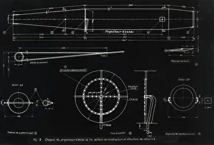
Background imagePlan Collection: German WWII ramjet engine blueprint

German WWII ramjet engine blueprint. This design, for the propulsor ramjet engine to be mounted on top of a Dornier Do 217 E-2 heavy bomber, dates from 1942

Background imagePlan Collection: Cromwell and the Vaudois (Cromwell, Protector of the Protestants of the Vaudois)

Cromwell and the Vaudois (Cromwell, Protector of the Protestants of the Vaudois)
Oil on Canvas 78.7 x 96.5 Brown, Ford Maddox

Background imagePlan Collection: PARIS IN 1578

PARIS IN 1578
A fascinating plan of the city, showing the inner and outer walls, the suburbs, the islands; the Tuileries, so central today, are actually outside the city wall

Background imagePlan Collection: Capability Brown plan F891571

Capability Brown plan F891571
AUDLEY END, SAFFRON WALDEN, ESSEX Colour-tinted landscape design plan of the Audley End estate in the 1770s, by Lancelot Capability Brown c. 1770 - 1780 Scale uncertain

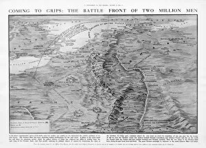
Background imagePlan Collection: The Western Front battleground - map of August 1914

The Western Front battleground - map of August 1914
WW1 - The Western Front battleground - map of August 1914 Date: 1914

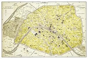
Background imagePlan Collection: Map of Paris 1894

Map of Paris 1894
map/plan of the city of Paris, France

Background imagePlan Collection: Plan of Bremenium, 1902

Plan of Bremenium, 1902. Bremenium was an ancient Roman fort (castra) located at Rochester, Northumberland, England. The fort was one of the defensive structures built along Dere Street

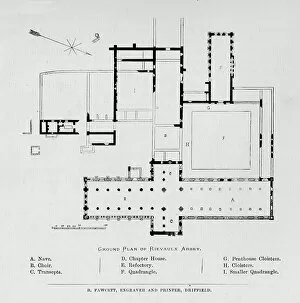
Background imagePlan Collection: Ground Plan of Rievaulx Abbey, 1897

Ground Plan of Rievaulx Abbey, 1897. From The Ruined Abbeys of Britain by Frederick Ross. [William Mackenzie, London, 1897]

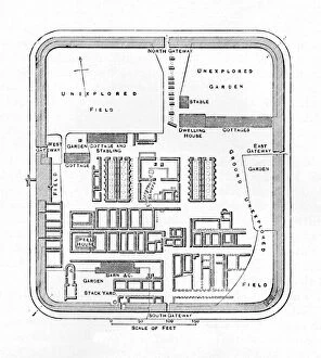
Background imagePlan Collection: Plan of the Defences at Rorkes Drift, (Jan. 22, 1879), c1880

Plan of the Defences at Rorkes Drift, (Jan. 22, 1879), c1880
Plan of the Defences at Rorkes Drift (Jan. 22, 1879), c1880. Episode of the Anglo-Zulu Wars (1879-1896). From British Battles on Land and Sea, Vol. IV, by James Grant

Background imagePlan Collection: Plan of the Marches near Isandhlwana between Jan. 12th and 22nd, 1879, c1880

Plan of the Marches near Isandhlwana between Jan. 12th and 22nd, 1879, c1880. From British Battles on Land and Sea, Vol. IV, by James Grant. [Cassell Petter & Galpin, London, Paris & Melbourne, c1880]

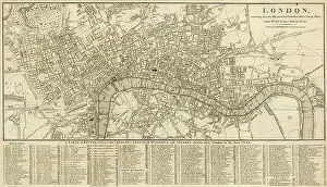
Background imagePlan Collection: London Map 1806

London Map 1806
London extending from the head of the Paddington Canal West, and to the West India Docks East. Date: 1806

Background imagePlan Collection: King David. Drawing for the rose window of the Cathedral of

King David. Drawing for the rose window of the Cathedral of Leon. 14th century. Paper, gouache. Leon Cathedral Chapter. Castile and Leon. Spain

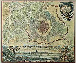
Background imagePlan Collection: Austria. Vienna. Plan, 1720

Austria. Vienna. Plan, 1720
Austria. Vienna. Plan of the walled city with Prater and the Danube River. Engraving, 1720

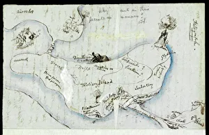
Background imagePlan Collection: Pen and ink sketch by B. Waterhouse Hawkins

Pen and ink sketch by B. Waterhouse Hawkins
Sketch on the reverse of a letter dated 24 October 1855, written to Professor Richard Owen from Benjamin Waterhouse Hawkins Date: 1855

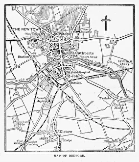
Background imagePlan Collection: Map of the City of Bedford, England Victorian Engraving, 1840

Map of the City of Bedford, England Victorian Engraving, 1840
Very Rare, Beautifully Illustrated Antique Engraving of Map of the City of Bedford, England Victorian Engraving, 1840. Source: Original edition from my own archives

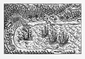
Background imagePlan Collection: Island of Principe Historical Map by Van Noort, Circa 1598

Island of Principe Historical Map by Van Noort, Circa 1598
Very Rare, Beautifully Illustrated Antique Engraved Victorian Illustration of Historical Map of Van Noort at the Island of Principe, 1598. Copyright has expired on this artwork. Digitally restored

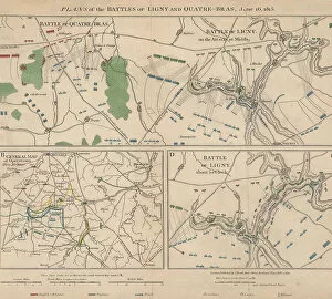
Background imagePlan Collection: Napoleonic Wars

Napoleonic Wars
Plans of the battle of Ligny and Quatre-Bras in Belgium during the Napoleonic Wars, 16th June 1815. Here Napoleon Bonaparte defeated the Prussian Army under Gebhard von Blucher

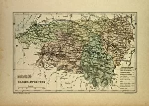
Background imagePlan Collection: Map of Basses-Pyrenees, France

Map of Basses-Pyrenees, France

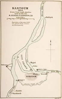
Background imagePlan Collection: Kartoum, Sudan, 1884, from The Journals of Major-General C. G. Gordon, C. B. at Kartoum

Kartoum, Sudan, 1884, from The Journals of Major-General C. G. Gordon, C. B. at Kartoum
KW259860 Kartoum, Sudan, 1884, from The Journals of Major-General C.G. Gordon, C.B. at Kartoum, published by Kegan Paul Trench & Co

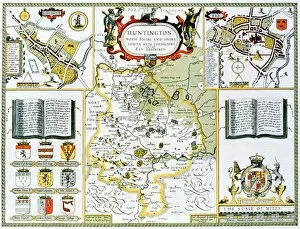
Background imagePlan Collection: Huntington, engraved by Jodocus Hondius (1563-1612) from John Speeds Theatre

Huntington, engraved by Jodocus Hondius (1563-1612) from John Speeds Theatre
XCF113473 Huntington, engraved by Jodocus Hondius (1563-1612) from John Speeds Theatre of the Empire of Great Britain, pub

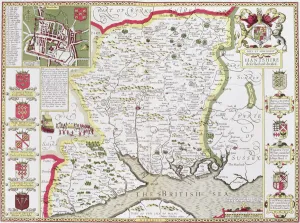
Background imagePlan Collection: Hantshire, engraved by Jodocus Hondius (1563-1612) from John Speeds Theatre

Hantshire, engraved by Jodocus Hondius (1563-1612) from John Speeds Theatre
XCF113466 Hantshire, engraved by Jodocus Hondius (1563-1612) from John Speeds Theatre of the Empire of Great Britain, pub

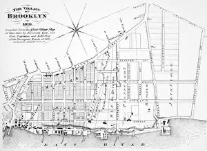
Background imagePlan Collection: Map of the village of Brooklyn, New York, in 1816

Map of the village of Brooklyn, New York, in 1816
BROOKLYN MAP, 1816. Map of the village of Brooklyn, New York, in 1816

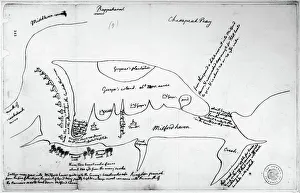
Background imagePlan Collection: Map drawn by Thomas Jefferson of Milford Haven on Chesapeake Bay and vicinity

Map drawn by Thomas Jefferson of Milford Haven on Chesapeake Bay and vicinity
CHESAPEAKE BAY, 1776. Map drawn by Thomas Jefferson of Milford Haven on Chesapeake Bay and vicinity, showing camp on Gwynns Island and enemy fortifications, June or July 1776

Background imagePlan Collection: VENICE: MAP, 1546. Map of Venice by Cristoforo Sabbadino, 1546

VENICE: MAP, 1546. Map of Venice by Cristoforo Sabbadino, 1546

Background imagePlan Collection: County Lunatic Asylum, Aylesbury, Buckinghamshire

County Lunatic Asylum, Aylesbury, Buckinghamshire
Aerial view of the Buckinghamshire County Lunatic Asylum at Stone, near Aylesbury. The asylum, designed by Thomas Henry Wyatt and David Brandon, was opened in 1853

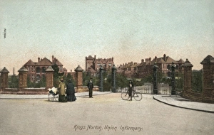
Background imagePlan Collection: Union Workhouse Infirmary, Kings Norton, Worcestershire

Union Workhouse Infirmary, Kings Norton, Worcestershire
The pavilion-plan infirmary erected in 1897 adjacent to the Kings Norton Union workhouse on what is now Raddlebarn Road, Kings Norton, Worcestershire, south west of Birmingham

Background imagePlan Collection: University of London

University of London
A panorama of the Bloomsbury area of London showing how Senate House, designed by Charles Holden, will fit in with the other University of London buildings

Background imagePlan Collection: Men of the British First Airborne Division in a glider; Seco

Men of the British First Airborne Division in a glider; Seco
Photograph showing a unit of the British First Airborne Division in a glider on the way to Arnhem, September 1944. On 17th September 1944 Operation Market Garden was put into action; a bold plan

Background imagePlan Collection: British First Airborne Troops using a mortar, Arnhem; Second

British First Airborne Troops using a mortar, Arnhem; Second
Photograph showing men of the British First Airborne Division using a 3-inch mortar in one of the woods surrounding Arnhem, in Holland, September 1944

Background imagePlan Collection: Rome / Colosseum 1855

Rome / Colosseum 1855
Plan of the various levels of the building : the lowest level is on the lower right, and the three higher levels are shown anti-clockwise

Background imagePlan Collection: Colour cross-section plan of Castle Class Locomotive, c. 1923

Colour cross-section plan of Castle Class Locomotive, c. 1923
Colour cross-section plan of Castle Class locomotive with the parts numbered, c.1923

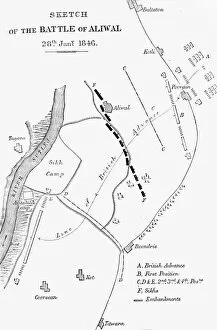
Background imagePlan Collection: Plan of the Battle of Aliwal, c1891. Creator: James Grant

Plan of the Battle of Aliwal, c1891. Creator: James Grant
Plan of the Battle of Aliwal, c1891. From " Cassells Illustrated History of India Vol. II.", by James Grant. [Cassell Petter & Galpin, London, Paris and New York]

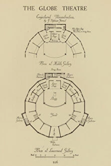
Background imagePlan Collection: Shakespeares Globe Theatre, Southwark, London (litho)

Shakespeares Globe Theatre, Southwark, London (litho)
7172912 Shakespeares Globe Theatre, Southwark, London (litho) by Forrest, George Topham (1872-1945); Private Collection; (add.info.: Shakespeares Globe Theatre, Southwark, London)

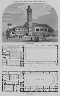
Background imagePlan Collection: Corporation Public Baths, Ashton-under-Lyne (engraving)

Corporation Public Baths, Ashton-under-Lyne (engraving)
5204543 Corporation Public Baths, Ashton-under-Lyne (engraving) by English School, (19th century); Private Collection; (add.info.: Corporation Public Baths, Ashton-under-Lyne)

Background imagePlan Collection: Plan of Bosworth Field, Battle of Bosworth, near Leicester, 22 August 1485

Plan of Bosworth Field, Battle of Bosworth, near Leicester, 22 August 1485, towards the end of the Wars of the Roses (1455-1487). Date: 1485

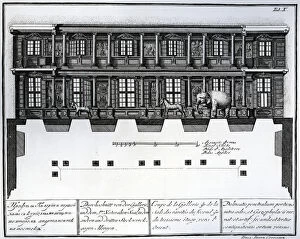
Background imagePlan Collection: Section view of the second and third floor of the Hall of Rarities looking eastwards

Section view of the second and third floor of the Hall of Rarities looking eastwards
XJF444306 Section view of the second and third floor of the Hall of Rarities looking eastwards, illustration in Chambers of the St

Background imagePlan Collection: Residence, Wilderwick, East Grinstead, Sussex (engraving)

Residence, Wilderwick, East Grinstead, Sussex (engraving)
5204585 Residence, Wilderwick, East Grinstead, Sussex (engraving) by English School, (19th century); Private Collection; (add.info.: Residence, Wilderwick, East Grinstead, Sussex, Mr Alfred Smith)

Background imagePlan Collection: Ground Plan of a Tower of Silence, View of the Interior (b / w photo)

Ground Plan of a Tower of Silence, View of the Interior (b / w photo)
2810814 Ground Plan of a Tower of Silence, View of the Interior (b/w photo) by English photographer, (19th century) (after); Private Collection; (add.info.: Ground Plan of a Tower of Silence)

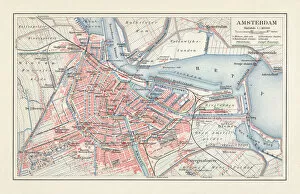
Background imagePlan Collection: City map of Amsterdam, Netherlands, lithograph, published in 1897

City map of Amsterdam, Netherlands, lithograph, published in 1897
City map of Amsterdam, capital of the Netherlands. Lithograph, published in 1897

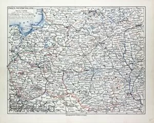
Background imagePlan Collection: Map of Poland, Belarus and Ukraine, 1899

Map of Poland, Belarus and Ukraine, 1899

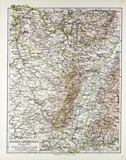
Background imagePlan Collection: Map of Elsass-Lothringen, 1899

Map of Elsass-Lothringen, 1899

Background imagePlan Collection: Map of Ancient Rome (etching) (b / w photo)

Map of Ancient Rome (etching) (b / w photo)
XJF324409 Map of Ancient Rome (etching) (b/w photo) by English School, (16th century); Private Collection; English, out of copyright

Background imagePlan Collection: Map of Manchester, 1751 (engraving)

Map of Manchester, 1751 (engraving)
XJF466271 Map of Manchester, 1751 (engraving) by Casson & Berry (fl.1750); Private Collection; (add.info.: image also shows a panorama of the city, as well as an view of St)

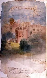
Background imagePlan Collection: The Globe Theatre, Southwark, London 1616. View of the Globe by the Dutch engraver

The Globe Theatre, Southwark, London 1616. View of the Globe by the Dutch engraver, Claes Jansz Visscher (1587-1652) draughtsman, engraver, cartographer

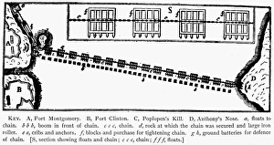
Background imagePlan Collection: Plan of the chain across the Hudson River at Fort Montgomery

Plan of the chain across the Hudson River at Fort Montgomery
REVOLUTIONAY WAR PLAN. Plan of the chain across the Hudson River at Fort Montgomery

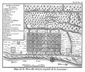
Background imagePlan Collection: Plan of New Orleans, Louisiana, 1718-1720: engraving, French, 1753

Plan of New Orleans, Louisiana, 1718-1720: engraving, French, 1753
NEW ORLEANS, 1718-1720. Plan of New Orleans, Louisiana, 1718-1720: engraving, French, 1753

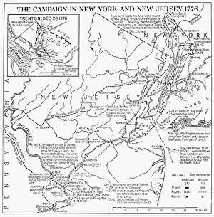
Background imagePlan Collection: Plan of the campaign in New York and New Jersey during the American Revolutionary War, 1776

Plan of the campaign in New York and New Jersey during the American Revolutionary War, 1776
REVOLUTIONARY WAR MAP, 1776 Plan of the campaign in New York and New Jersey during the American Revolutionary War, 1776


All Professionally Made to Order for Quick Shipping

"Unveiling the Blueprint of Success: The Power of a Well-Crafted Plan" In every era, plans have shaped destinies and transformed history. From the meticulously detailed Swindon Works Map in the 1940s to the strategic D-Day Map of 1944, maps have guided armies towards victory and nations towards liberation. The grandeur of empires is etched on maps like the British Empire's expansive territories, reminding us that meticulous planning can forge vast dominions. Even legendary figures like Admiral Nelson relied on precise battle plans to secure triumph at Trafalgar in 1805. Beyond military conquests, plans have given rise to architectural marvels. Filippo Brunelleschi's ingenious design for Santa Maria del Fiore Cathedral in Florence showcased his visionary plan through Lodovico Cardi da Cigoli's contemporary drawing. This cross-section blueprint exemplifies how careful planning can manifest breathtaking beauty. Yet not all plans come to fruition unscathed. The Titanic blueprint serves as a haunting reminder that even with meticulous preparations, unforeseen circumstances may arise. Nevertheless, it underscores the importance of thorough planning and risk assessment. From historic battles such as Waterloo or Chancellorsville during the US Civil War where General Lee and General Jackson strategized their moves before engaging in combat, we witness how well-executed they can turn tides amidst chaos and uncertainty. Even ancient times bear testament to strategic brilliance; Hannibal's Battle of Cannae plan from 216 BC showcases his tactical genius by encircling enemy forces—an enduring lesson in outmaneuvering adversaries. Plans extend beyond warfare; they shape our world at large. Whether it be mapping zoological wonders like London Zoo in 1929 or charting geographical landscapes like an old map detailing the majestic Alps—plans enable exploration and understanding of our surroundings while fostering conservation efforts for future generations. In essence, these diverse examples remind us that behind every triumph, there lies a well-crafted plan.