
Martines Collection
"Exploring the World through Martines' Maps: A Glimpse into 16th Century Cartography" Step back in time and immerse yourself in the intricate world of Joan Martines


All Professionally Made to Order for Quick Shipping
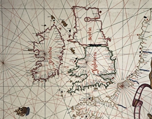
"Exploring the World through Martines' Maps: A Glimpse into 16th Century Cartography" Step back in time and immerse yourself in the intricate world of Joan Martines, a renowned cartographer from the 16th century. His maps offer us a fascinating glimpse into the past, showcasing his remarkable skills and attention to detail. One of his notable works is the Spanish map of England, Scotland, and Ireland. This masterpiece not only provides geographical information but also reflects historical connections between these countries during that era. Similarly, Martines' Portolan of Joan Martines takes us on a visual journey across Europe and coasts of North Africa, allowing us to trace ancient trade routes and discover how different regions were connected. In his Atlas of Joan Martines from Messina in 1582, we find portulan charts depicting various parts of the world. For instance, there is a detailed chart showcasing Sicily's coastal features - an invaluable resource for sailors navigating those treacherous waters. Another highlight is his portrayal of South America; with its vibrant colors and precise markings, it offers insights into early European exploration in this part of the world. Martines' expertise extends beyond known lands as well. His portolan atlas reveals details about America's west coast during that time period - an area still being explored by adventurers like him. Additionally, he created captivating maps illustrating South America's diverse landscapes along with its western coastline (specifically Peru). These maps shed light on how Europeans perceived these newly discovered territories. The significance of Martines' work cannot be overstated; it serves as a testament to human curiosity and our desire to understand our surroundings better. Through his meticulous craftsmanship and dedication to accuracy, he has left behind an enduring legacy that continues to captivate historians today.