Fraud Blocker Skip to main content

Gulf Of Suez Collection

The Gulf of Suez, a historical and captivating region, holds numerous tales within its waters

Background imageGulf Of Suez Collection: Antique map of the Middle East with Egypt, Syria, and Israel

Antique map of the Middle East with Egypt, Syria, and Israel. Date unknown

Background imageGulf Of Suez Collection: 'Peninsule du Sinai; Le Nord-Est Africain, 1914. Creator: Unknown

'Peninsule du Sinai; Le Nord-Est Africain, 1914. Creator: Unknown
'Peninsule du Sinai; Le Nord-Est Africain, 1914. From "Grande Geographie Bong Illustree", 1914

Background imageGulf Of Suez Collection: Diorama of the Route of the Overland Mail to India - Leaving Suez, 1850. Creator: Unknown

Diorama of the Route of the Overland Mail to India - Leaving Suez, 1850. Creator: Unknown
Diorama of the Route of the Overland Mail to India - Leaving Suez, 1850. Display...at the Gallery of Illustration, in the house No. 14, Regent-street [in London] built by Mr

Background imageGulf Of Suez Collection: Map of the Turkish attack on the Suez Canal, Egypt, First World War, 1915, (c1920)

Map of the Turkish attack on the Suez Canal, Egypt, First World War, 1915, (c1920). Map showing approximately the direction of the Turkish Attack on the Suez Canal, January 25 - February 3, 1915

Background imageGulf Of Suez Collection: Suez Canal, ship entering the Red Sea near Port Tewfic, c. 1900 (colour photochrom)

Suez Canal, ship entering the Red Sea near Port Tewfic, c. 1900 (colour photochrom)
5322734 Suez Canal, ship entering the Red Sea near Port Tewfic, c.1900 (colour photochrom); Private Collection; (add.info)

Background imageGulf Of Suez Collection: The Wreck of the Bombay Mail-Steamer Carnatic at Shadwan, Gulf of Suez (engraving)

The Wreck of the Bombay Mail-Steamer Carnatic at Shadwan, Gulf of Suez (engraving)
1104285 The Wreck of the Bombay Mail-Steamer Carnatic at Shadwan, Gulf of Suez (engraving) by Weedon, Edwin (1819-79); Private Collection; (add.info)

Background imageGulf Of Suez Collection: The Island of Shadwan, Gulf of Suez, where the Bombay Mail Steam-Packet Carnatic was wrecked

The Island of Shadwan, Gulf of Suez, where the Bombay Mail Steam-Packet Carnatic was wrecked (engraving)
1104246 The Island of Shadwan, Gulf of Suez, where the Bombay Mail Steam-Packet Carnatic was wrecked (engraving) by English School

Background imageGulf Of Suez Collection: Another Marine Monster! (engraving)

Another Marine Monster! (engraving)
1054293 Another Marine Monster! (engraving) by English School, (19th century); Private Collection; (add.info.: Another Marine Monster)

Background imageGulf Of Suez Collection: Port Tewfic, entrance to the Suez Canal, c. 1900 (colour photochrom)

Port Tewfic, entrance to the Suez Canal, c. 1900 (colour photochrom)
5322733 Port Tewfic, entrance to the Suez Canal, c.1900 (colour photochrom); Private Collection; (add.info.: Suez Canal which connects the Mediterranean Sea to the Red Sea through the Isthmus of Suez)

Background imageGulf Of Suez Collection: Recovering the Cargo of the Carnatic off Shadwan, in the Gulf of Suez (engraving)

Recovering the Cargo of the Carnatic off Shadwan, in the Gulf of Suez (engraving)
1104361 Recovering the Cargo of the Carnatic off Shadwan, in the Gulf of Suez (engraving) by English School, (19th century); Private Collection; (add.info)

Background imageGulf Of Suez Collection: Earth from space - the Sinai Peninsula, Egypt, c1980s. Creator: NASA

Earth from space - the Sinai Peninsula, Egypt, c1980s. Creator: NASA
Earth from space - the Sinai Peninsula, Egypt, c1980s. Showing the Gulf of Suez, the Red Sea and the Gulf of Aqaba

Background imageGulf Of Suez Collection: Suez, c1882

Suez, c1882. Episode of the Anglo-Egyptian War, (1882). From British Battles on Land and Sea, Vol. IV, by James Grant. [Cassell Petter & Galpin, London, Paris & Melbourne, c1880]

Background imageGulf Of Suez Collection: Antique map of the Gulf of Suez with Egypt and Israel

Antique map of the Gulf of Suez with Egypt and Israel

Background imageGulf Of Suez Collection: Antique map of the Gulf of Suez and Mount Sinai

Antique map of the Gulf of Suez and Mount Sinai

Background imageGulf Of Suez Collection: Antique map of the holy land of Sinai peninsula

Antique map of the holy land of Sinai peninsula

Background imageGulf Of Suez Collection: The Sinai Peninsula

The Sinai Peninsula
February 2000 - The Sinai Peninsula, located between Africa and Asia, is a result of those two continents pulling apart from each other

Background imageGulf Of Suez Collection: Satellite view of the Middle East

Satellite view of the Middle East
May 4, 2003 - Deserts stretch across the Middle East in shades of tan, pink, and orange, while green foothills, mountains, and plains mark their edges

Background imageGulf Of Suez Collection: High oblique scene looking toward the Sinai Peninsula and the Mediterranean Sea

High oblique scene looking toward the Sinai Peninsula and the Mediterranean Sea
May 12, 2009 - High oblique scene looking toward the Sinai Peninsula and the Mediterranean Sea. The Red Sea is just out of frame at bottom right

Background imageGulf Of Suez Collection: The Sinai Peninsula and the Dead Sea Rift

The Sinai Peninsula and the Dead Sea Rift
March 1-12, 2002 - The astronauts on board the Space Shuttle Columbia took this 70mm picture featuring the Sinai Peninsula and the Dead Sea Rift

Background imageGulf Of Suez Collection: Satellite view of Cairo, Egypt, and the valley of the Nile River

Satellite view of Cairo, Egypt, and the valley of the Nile River
April 11, 2011 - Satellite view of Cairo, Egypt, and the valley of the Nile River. The valley of the Nile River, a rich agricultural region

Background imageGulf Of Suez Collection: Aerial view of the Egypt and the Sinai Peninsula along with part of the Mediterranean Sea

Aerial view of the Egypt and the Sinai Peninsula along with part of the Mediterranean Sea
July 17, 2009 - The Nile River and its delta in Egypt and the Sinai Peninsula and part of the Mediterranean Sea and Red Sea are just a few of the geographic features recognizable in this photograph

Background imageGulf Of Suez Collection: Gulf of Suez, Egypt, from nautical charts by Joao de Castro, 1538

Gulf of Suez, Egypt, from nautical charts by Joao de Castro, 1538
Cartography, 16th century. The Gulf of Suez, from the nautical charts by Joao de Castro, 1538

Background imageGulf Of Suez Collection: Nile Delta, satellite image

Nile Delta, satellite image
Nile Delta, Egypt, satellite image. North is at top. The River Nile flows from bottom, out of the deserts (light brown) of Egypt, and into the Mediterranean Sea (top, blue)

Background imageGulf Of Suez Collection: Nile delta & Sinai peninsula as seen from Shuttle

Nile delta & Sinai peninsula as seen from Shuttle
Shuttle Columbia image (mission STS-52) centred on the Sinai peninsula. It has a triangular shape and extends from centre with its tip at bottom right


All Professionally Made to Order for Quick Shipping

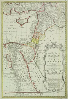
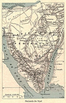
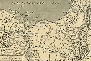
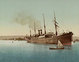
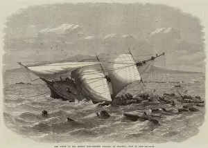
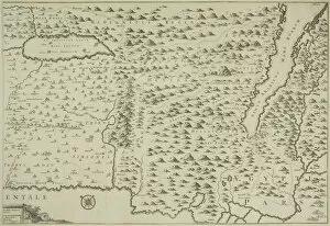
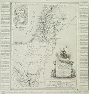
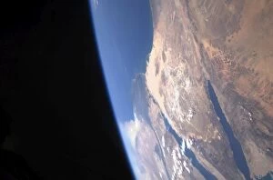
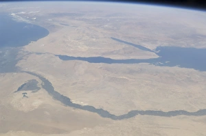
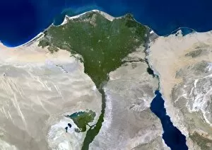
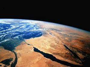
The Gulf of Suez, a historical and captivating region, holds numerous tales within its waters. As I gaze upon an antique map of the Middle East, Egypt, Syria, and Israel come to life before my eyes, and is here that the magnificent Suez Canal takes center stage - a gateway connecting continents. A vivid image captures my attention: a ship gracefully entering the Red Sea near Port Tewfic in 1900. The color photochrom transports me back in time, revealing the bustling maritime activity that once thrived in this area. But not all stories are filled with triumph. Engraved on paper lies the haunting scene of the wrecked Bombay Mail-Steamer Carnatic at Shadwan Island in the Gulf of Suez. The tragedy unfolds as another engraving depicts efforts to recover its precious cargo from these treacherous depths. Intriguingly, even marine monsters find their place amidst these narratives. An engraving showcases yet another mysterious creature lurking beneath these turquoise waters – a testament to both fear and fascination. Turning our attention towards history's pages, we encounter a map illustrating Turkey's attack on the Suez Canal during World War I. This visual representation allows us to grasp how significant this strategic location was during times of conflict. Zooming out into space brings forth an awe-inspiring sight: Earth viewed from above reveals Sinai Peninsula's majestic presence within Egypt. NASA's c1980s photograph reminds us of our planet's beauty and fragility simultaneously. Delving deeper into time again leads us to 1882 when Suez itself stood witness to events unfolding around it - perhaps hinting at moments that shaped its destiny forevermore. Finally, we find ourselves basking under sun umbrellas on Makman el Tiyha beach along Janub Sina in the Gulf of Suez. Here tranquility reigns supreme as visitors soak up golden rays while admiring stunning views across this captivating region.