mail_outline sales@mediastorehouse.com
Framed Print
Antique Framed Print
Premium Framed Print
Canvas Print
Metal Print
Photographic Print
Poster Print
Fine Art Print
Mounted Print
Glass Frame
Acrylic Blox
Jigsaw Puzzle
Tote Bag
Photo Mug
Greetings Card
Postcard
Cushion
Mouse Mat
Glass Place Mat
Glass Coaster
Carte de Tartarie, 1706. Creator: Guillaume DelisleCarte de Tartarie, 1706
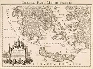
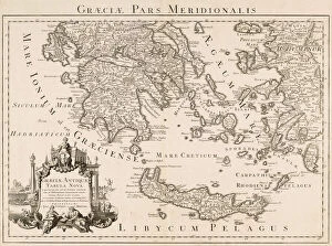
Map of ancient Greece and part of Turkey (engraving)7239665 Map of ancient Greece and part of Turkey (engraving) by Delisle, Guillaume (1675-1726) (after); Private Collection; (add.info.: Graeciae pars meridionalis. Graeciae antiquae tabula nova)
Map of Canada, published Paris, 1703 (hand-coloured engraving)NBY332310 Map of Canada, published Paris, 1703 (hand-coloured engraving) by Delisle, Guillaume (1675-1726) (after); 50x65 cm; Newberry Library, Chicago, Illinois
Map of Greece, its islands and neighbouring countries. After an early 18th century map by Guillaume De L Isle titled Accurata totius Archipelagi et Graeciae universae tabula. From R. and J
Graeciae pars meridionalis. Graeciae antiquae tabula nova. Southern Greece. A New Map of Ancient Greece. Parts of Asian Turkey are also shown
Carte de la Barbarie de la Nigritie et de la Guinee. Map of the Barbary and of the Nigritie and of Guinea. An early 18th century map by Guillaume de L Isle, also known as Guillaume Delisle
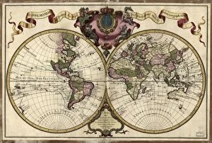
World Map. A Dutch edition of Guillaume De L Isles double hemisphere map of the World first published in Paris in 1720. It includes marked routes of major explorers
Map of the world, 172018th century map of the world. Published in Paris in 1720, this French map shows the known world, including the new lands that had been discovered in the preceding centuries by Europeans exploring