
Flood Defence Collection
"Flood Defence: Protecting London's Iconic Landmarks and Communities" London, England is no stranger to the threat of flooding


All Professionally Made to Order for Quick Shipping
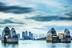
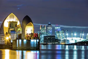
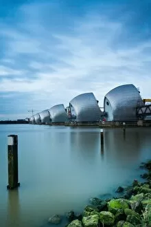
"Flood Defence: Protecting London's Iconic Landmarks and Communities" London, England is no stranger to the threat of flooding. With its iconic River Thames flowing through the heart of the city, measures have been taken over the years to safeguard both historic landmarks and bustling neighborhoods from this natural disaster. One such remarkable feat of engineering is the Thames Barrier on the River Thames, standing tall against potential floodwaters. Its imposing presence serves as a symbol of resilience and protection for Londoners. Against a backdrop that includes Canary Wharf, an emblematic financial district, this architectural marvel showcases how modernity intertwines with nature in this vibrant metropolis. At nightfall, when darkness blankets the cityscape, another breathtaking scene unfolds. The illuminated Millennium Dome (now known as O2 Arena) stands alongside Canary Wharf under a starry sky. This captivating image reminds us that even amidst urban splendor, flood defence remains paramount. Looking back into history reveals past struggles faced by London during floods. In 1928 and 1935, devastating floods swept through parts of the city leaving destruction in their wake. These haunting images captured by unknown photographers serve as reminders of why proactive measures are necessary to protect lives and infrastructure. Beyond London's borders lies Coryton Refinery—a vital industrial hub also threatened by flooding risks. Photographs from 1953 depict courageous efforts made to fortify these critical facilities against rising waters—an enduring testament to human determination in times of crisis. However, it is not just London that has battled against flooding throughout history. Across continents and centuries ago in New Orleans, USA—The Levee stood strong against surging waters depicted vividly in a chromolithograph from 1884; showcasing how communities worldwide have long grappled with protecting themselves from nature's wrath. Even railway systems have encountered challenges when confronted with floods—a collapse near St Erth captured in an evocative photograph dating back to 1901.