
Edgware Road Collection
Edgware Road, located in Gateshead NE8 3 Map, is a historic and vibrant area that holds significant cultural and historical value


All Professionally Made to Order for Quick Shipping
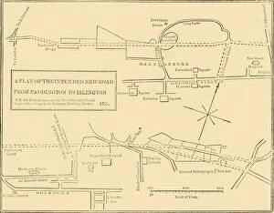
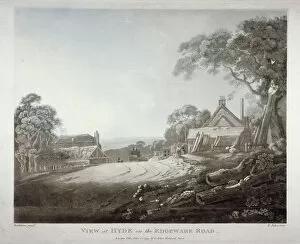
Edgware Road, located in Gateshead NE8 3 Map, is a historic and vibrant area that holds significant cultural and historical value. This bustling street in the heart of London has witnessed numerous events throughout its existence. In 2009, Ethel Davies captured the essence through her lens, showcasing the dynamic atmosphere that permeates this iconic location. The photographs depict a snapshot of life on this renowned street, where people from all walks of life come together. One notable event that took place on Edgware Road was the infamous Cato Street Conspiracy in 1820. A lithograph by an unknown artist portrays the hayloft in Cato Street where conspirators gathered to plot against the government. Another engraving showcases a view of Cato Street itself during this tumultuous time. The interior view etching offers insight into how these conspirators occupied their secret meeting place within the hayloft, and is fascinating to imagine what discussions unfolded within those walls as they planned their subversive actions. Moving forward in time, we see an aerial photograph capturing Marble Arch on Edgware Road. This black and white photo provides a unique perspective on one of London's most recognizable landmarks. Advertisements for L Kyezor and Messrs Breech and Berralls Silk highlight the commercial aspect of Edgware Road's history. These engravings give us glimpses into businesses that once thrived along this bustling thoroughfare. Delving further back into history, an engraving displays a ground plan from 1755 depicting New Road from Islington to Edgware Road. This serves as evidence of how important transportation routes have always been for connecting communities across different eras. Lastly, a poignant black and white photo captures London's signs of mourning for Queen Victoria. Even during times of grief and remembrance, life continues to flow through Edgware Road with its own unique rhythm.