Fraud Blocker Skip to main content

Dmsp Collection

"DSPM: Illuminating the World from Above" Capturing the mesmerizing beauty of our planet

Background imageDmsp Collection: Europe at night

Europe at night, satellite image. North is at top. Yellow lights mark the major cities and population areas, showing a clearly delineated Mediterranean coast

Background imageDmsp Collection: Europe at night, satellite image

Europe at night, satellite image. City lights (yellow) show areas of dense population. There are few lights in North Africa (bottom) and the Arctic (top) since they are more sparsely populated

Background imageDmsp Collection: North America at night, satellite image

North America at night, satellite image
Africa at night. Satellite image of the Earth at night, set against a background of stars, centred on the continent of Africa. North is at top. City lights (yellow) show areas of dense population

Background imageDmsp Collection: South America at night, satellite image

South America at night, satellite image
South America at night. Satellite image of the Earth at night, set against a background of stars, centred on the continent of South America. North is at top

Background imageDmsp Collection: South America at night, satellite image

South America at night, satellite image. City lights (yellow) show areas of dense population, particularly in North America (top left) and South Americas coasts

Background imageDmsp Collection: North America at night, satellite image

North America at night, satellite image. City lights (yellow) show areas of dense population, particularly in North America (upper centre)

Background imageDmsp Collection: Whole Earth, satellite image

Whole Earth, satellite image. This map is centred on the Greenwich meridian, at zero degrees latitude. Arctic and Antarctic ice is white, oceans are blue and land is green and brown

Background imageDmsp Collection: Africa, satellite image

Africa, satellite image
Africa. Satellite image of the Earth centred on Africa. Clouds are white, oceans are blue and land is green and brown. Also seen are Europe (top) Asia (upper right), the Indian Ocean (right)

Background imageDmsp Collection: Africa, night-day satellite image

Africa, night-day satellite image. This composite image of the Earth is set against a background of stars, and is centred on the continent of Africa. North is at top

Background imageDmsp Collection: Whole Earth at night, satellite image

Whole Earth at night, satellite image. This map is centred on the Greenwich meridian, at zero degrees latitude. City lights (yellow) show areas of dense population

Background imageDmsp Collection: Australia at night, satellite image

Australia at night, satellite image. City lights (yellow) show areas of more dense population, particularly in Southeast Asia (top left) and on Australias east coast

Background imageDmsp Collection: Europe, night-day satellite image

Europe, night-day satellite image. This composite image of the Earth is set against a background of stars, and is centred on Europe. North is at top

Background imageDmsp Collection: The Arctic, satellite image

The Arctic, satellite image
The Arctic. Satellite image of the Earth centred on the Arctic. The North Pole is at centre. Clouds and Arctic sea ice are white, oceans are blue and land is green and brown

Background imageDmsp Collection: Africa at night, satellite image

Africa at night, satellite image. City lights (yellow) show areas of dense population, particularly in Europe and the Middle East (top)

Background imageDmsp Collection: East Asia at night, satellite image

East Asia at night, satellite image
East Asia at night. Satellite image of the Earth at night, centred over China. City lights (yellow) show areas of dense population

Background imageDmsp Collection: Arctic ice minimum extent, 2012

Arctic ice minimum extent, 2012
Arctic ice minimum extent. Satellite image showing the Arctic polar ice cap at its annual minimum extent on 16th September 2012

Background imageDmsp Collection: Artic sea ice coverage, 1980 C014 / 4710

Artic sea ice coverage, 1980 C014 / 4710
Artic sea ice coverage, 1980. Map showing the changes in Arctic sea ice coverage from 1st November 1979 to 31st January 1980

Background imageDmsp Collection: Arctic ice minimum extent, 2005

Arctic ice minimum extent, 2005
Arctic sea ice minimum extent, 2005. The extent of the sea ice varies over the course of a year, being largest in winter and smallest in summer

Background imageDmsp Collection: The Arctic, night-day satellite image

The Arctic, night-day satellite image
Asia, night-day satellite image. This composite image of the Earth is set against a background of stars, and is centred on the continent of Asia. North is at top

Background imageDmsp Collection: Asia at night, satellite image

Asia at night, satellite image. City lights (yellow) show areas of dense population. Large, densely populated areas include India (lower centre), China (lower right) and Japan (right)

Background imageDmsp Collection: Arabian Sea, satellite image

Arabian Sea, satellite image
Arabian Sea. Satellite image of the Earth centred on the Arabian Sea and western India. Clouds and Arctic ice (top) are white, oceans are blue and land is green and brown

Background imageDmsp Collection: The Americas, satellite image

The Americas, satellite image
The Americas. Satellite image of the Earth centred on the Caribbean Islands, with North America at upper left and South America at bottom

Background imageDmsp Collection: Northern Asia and the Arctic

Northern Asia and the Arctic. Satellite image of the Earth centred on Siberia, with the North Pole at upper centre. Clouds and Arctic sea ice are white, oceans are blue and land is green and brown


All Professionally Made to Order for Quick Shipping

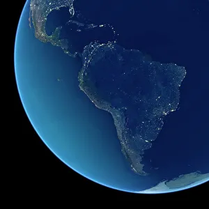
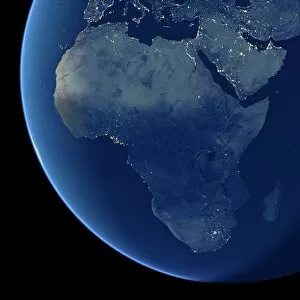
"DSPM: Illuminating the World from Above" Capturing the mesmerizing beauty of our planet, DSPM (Defense Meteorological Satellite Program) provides us with breathtaking satellite images that showcase different regions of Earth at night. From Europe to North America, South America to Africa, and even Australia, these captivating snapshots offer a unique perspective on our world. In one image, we witness the twinkling lights that adorn Europe at night. The vibrant cities and bustling metropolises create a dazzling tapestry across the continent. Moving across the Atlantic Ocean, another snapshot reveals North America's urban sprawl illuminated against the dark backdrop of nature. Venturing further southward in South America's direction unveils yet another stunning view as city lights illuminate its landscapes. The contrast between densely populated areas and vast stretches of untouched wilderness is truly awe-inspiring. Shifting focus back to Africa, DSPM presents us with an intricate satellite image showcasing this diverse continent during both day and night. Witnessing how civilization blends seamlessly into nature during daylight hours while transforming into clusters of light after sunset is nothing short of remarkable. Zooming out for a wider perspective, we are treated to a breathtaking satellite image capturing the entire globe at night – an awe-inspiring sight where continents are adorned by countless glowing dots representing human activity amidst darkness. DSPM also takes us Down Under as it captures Australia at night from above. Vibrant coastal cities stand out against vast expanses of uninhabited land down below—a testament to humanity's ability to thrive even in remote corners of our planet. Finally, returning once again to North America through another striking satellite image—this time focusing on specific details—we can observe various geographical features like mountain ranges or rivers under a new light—the artificial glow emanating from human settlements contrasting with natural formations beneath them. Through DSPM's incredible imagery captured by satellites orbiting high above Earth’s atmosphere, we gain not only visual delight but also a deeper appreciation for the interconnectedness of our world.