
City Planning Collection
"City Planning: A Tapestry of Vision, Innovation, and Transformation" Embarking on a journey through the annals of urban development


All Professionally Made to Order for Quick Shipping
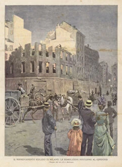
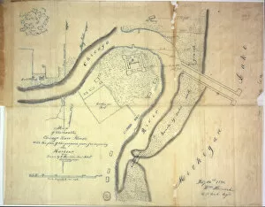
"City Planning: A Tapestry of Vision, Innovation, and Transformation" Embarking on a journey through the annals of urban development, we witness the remarkable stories etched into the fabric of cities across continents. From the iconic Olympic Stadium in Beijing to the captivating Museum of Beijing City Planning, China's capital stands as a testament to meticulous foresight and architectural brilliance. Transporting ourselves back in time, we find Dundee's Riverside Drive project envisioned by artists in 1918. Their brushstrokes captured an idyllic vision for a harmonious blend between nature and infrastructure. Similarly, Vienna's Prater unveils its grandeur through an enchanting engraving from 1821, showcasing an avenue that has withstood centuries while evolving with modernity. The dynamism is not limited to aesthetics alone; it encompasses revitalization too. Milan's night demolitions at Cordusio epitomize progress as old structures make way for new beginnings. Meanwhile, Chicago River's proposed piers reveal how strategic planning can shape waterways into thriving economic hubs. Delving deeper into history reveals New York City's transformational journey depicted on topographical maps from 1865 - showcasing both natural watercourses and reclaimed land that now form Manhattan's bustling streetscapes. The adjacent country seamlessly merges with urban landscapes in this tapestry of growth. London emerges as another protagonist in this narrative - Bloomsbury witnesses sewer construction while Lower Bedford Place sees well-digging efforts unfold before our eyes. Moorfields' sewers expand under skilled hands during London’s Victorian era when sanitation became paramount. Tottenham Court Road bears witness to the laying of a vital water-main network that would quench Londoner’s thirsts since 1834. As we explore these vignettes spanning continents and centuries alike, one truth becomes evident.