Fraud Blocker Skip to main content

Chart Collection (page 13)

"Unlocking the Secrets: Exploring the Fascinating World of Charts" Dive into the realm of reflexology with a detailed foot map chart

Background imageChart Collection: The worlds sources of supply, tea and coffee, cocoa and wine (colour litho)

The worlds sources of supply, tea and coffee, cocoa and wine (colour litho)
3648945 The worlds sources of supply, tea and coffee, cocoa and wine (colour litho) by English School, (20th century); Private Collection; (add.info.: The worlds sources of supply, tea and coffee)

Background imageChart Collection: The worlds sources of supply, meat, wheat (colour litho)

The worlds sources of supply, meat, wheat (colour litho)
3648940 The worlds sources of supply, meat, wheat (colour litho) by English School, (20th century); Private Collection; (add.info.: The worlds sources of supply, meat, wheat)

Background imageChart Collection: The world, commercial languages, The world, postal (colour litho)

The world, commercial languages, The world, postal (colour litho)
3648935 The world, commercial languages, The world, postal (colour litho) by English School, (20th century); Private Collection; (add.info.: The world, commercial languages, The world, postal)

Background imageChart Collection: Merchant flags (colour litho)

Merchant flags (colour litho)
3648930 Merchant flags (colour litho) by English School, (20th century); Private Collection; (add.info.: Merchant flags. Illustration for Philips Chamber of Commerce Atlas)

Background imageChart Collection: Copper (colour litho)

Copper (colour litho)
3648650 Copper (colour litho) by English School, (20th century); Private Collection; (add.info.: Copper. Illustration for Atlas of the Worlds Commerce compiled from the latest official returns at)

Background imageChart Collection: Distribution of fisheries (colour litho)

Distribution of fisheries (colour litho)
3648635 Distribution of fisheries (colour litho) by English School, (20th century); Private Collection; (add.info.: Distribution of fisheries)

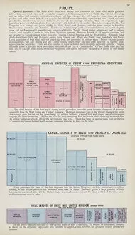
Background imageChart Collection: Fruit (colour litho)

Fruit (colour litho)
3648625 Fruit (colour litho) by English School, (20th century); Private Collection; (add.info.: Fruit. Illustration for Atlas of the Worlds Commerce compiled from the latest official returns at)

Background imageChart Collection: Fruit (colour litho)

Fruit (colour litho)
3648623 Fruit (colour litho) by English School, (20th century); Private Collection; (add.info.: Fruit. Illustration for Atlas of the Worlds Commerce compiled from the latest official returns at)

Background imageChart Collection: Cocoa and spices (colour litho)

Cocoa and spices (colour litho)
3648622 Cocoa and spices (colour litho) by English School, (20th century); Private Collection; (add.info.: Cocoa and spices)

Background imageChart Collection: Tea (colour litho)

Tea (colour litho)
3648613 Tea (colour litho) by English School, (20th century); Private Collection; (add.info.: Tea. Illustration for Atlas of the Worlds Commerce compiled from the latest official returns at)

Background imageChart Collection: Wheat, growing countries (colour litho)

Wheat, growing countries (colour litho)
3648598 Wheat, growing countries (colour litho) by English School, (20th century); Private Collection; (add.info.: Wheat, growing countries)

Background imageChart Collection: Commercial highways of the world (colour litho)

Commercial highways of the world (colour litho)
3648590 Commercial highways of the world (colour litho) by English School, (20th century); Private Collection; (add.info.: Commercial highways of the world)

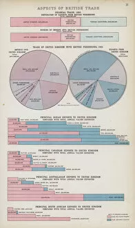
Background imageChart Collection: Aspects of British trade (colour litho)

Aspects of British trade (colour litho)
3648586 Aspects of British trade (colour litho) by English School, (20th century); Private Collection; (add.info.: Aspects of British trade)

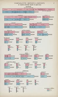
Background imageChart Collection: Comparative imports and exports of various countries drawn to same scale (colour litho)

Comparative imports and exports of various countries drawn to same scale (colour litho)
3648583 Comparative imports and exports of various countries drawn to same scale (colour litho) by English School, (20th century); Private Collection; (add.info)

Background imageChart Collection: Density of population, 1906, Western hemisphere, Eastern hemisphere, United States, India

Density of population, 1906, Western hemisphere, Eastern hemisphere, United States, India, Europe (colour litho)
3648577 Density of population, 1906, Western hemisphere, Eastern hemisphere, United States, India, Europe (colour litho) by English School

Background imageChart Collection: Harvest of apples in Normandy, France (engraving)

Harvest of apples in Normandy, France (engraving)
2334807 Harvest of apples in Normandy, France (engraving) by Unknown Artist, (19th century); (add.info.: View champetre of the harvest of apples in Normandy (France), for the manufacture of cider

Background imageChart Collection: Winifred Atwell on the cover of her recording of Make it a P

Winifred Atwell on the cover of her recording of Make it a Party which was a top ten chart success. Winifred Atwell (1914-1983)

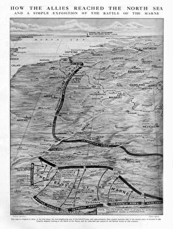
Background imageChart Collection: WW1 - How Allies reached the North Sea - Battle of the Marne

WW1 - How Allies reached the North Sea - Battle of the Marne 1914

Background imageChart Collection: WW1 - The War in the East - Russias progress - 1914

WW1 - The War in the East - Russias progress - 1914. 1914

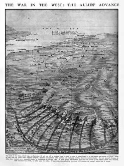
Background imageChart Collection: WW1 - The War in the West - The Allies Advance - 1914

WW1 - The War in the West - The Allies Advance - 1914. The Battle of the Aisne. 1914

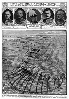
Background imageChart Collection: WW1 - Mons and our Masterly Move - 1914

WW1 - Mons and our Masterly Move - 1914
WW1 - Mons and our Masterly Move - Field Marshall Sir John Frenchs Historical Dispatch explained. A pictorial map showing the famous British Expeditionary Force (BEF)

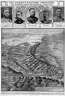
Background imageChart Collection: WW1 - The Enemys Eastern Frontier - 1914

WW1 - The Enemys Eastern Frontier - 1914
WW1 - The Enemys Eastern Frontier - The Splendid work of Russian Strategy. Pictorial map showing the strategy of Russian Commanders

Background imageChart Collection: Columbus First Sight of Land

Columbus First Sight of Land
Christopher Columbus stands on the deck of his ship at night, looking off into the distance with his hand on a map. A sailor named Rodrigo de Triana spotted the land first

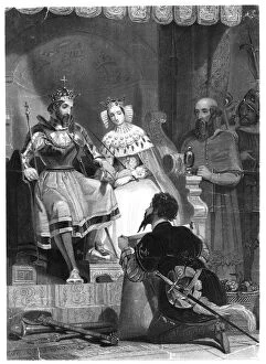
Background imageChart Collection: Columbus explains his plans to Ferdinand and Isabella c. 1492

Columbus explains his plans to Ferdinand and Isabella c. 1492
Christopher Columbus explains his plans to Ferdinand and Isabella in the royal court. Columbus kneels holding a scroll, as Ferdinand and Isabella listen from their thrones. Date: 1492

Background imageChart Collection: Columbus outlines project to The Council at Salamanca

Columbus outlines project to The Council at Salamanca
Christopher Columbus outlines project to the Council at Salamanca Spain in January 1492, holding up a map as he explains his intended route across the Atlantic. Date: 1492

Background imageChart Collection: The Wreck of HMS Wasp (engraving)

The Wreck of HMS Wasp (engraving)
1622808 The Wreck of HMS Wasp (engraving) by English School, (19th century); Private Collection; (add.info.: The Wreck of HMS Wasp. Illustration for The Illustrated London News, 4 October 1884)

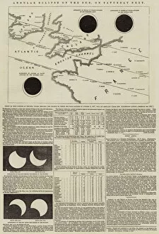
Background imageChart Collection: Annular Eclipse of the Sun, on Saturday Next (engraving)

Annular Eclipse of the Sun, on Saturday Next (engraving)
1096146 Annular Eclipse of the Sun, on Saturday Next (engraving) by English School, (19th century); Private Collection; (add.info.: Annular Eclipse of the Sun, on Saturday Next)

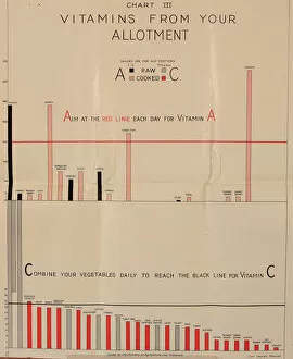
Background imageChart Collection: Poster, Chart III, vitamins from your allotment, WW2

Poster, Chart III, vitamins from your allotment, WW2
Poster, Chart III, vitamins from your allotment - how to get enough Vitamin A and Vitamin C each day. 1940s

Background imageChart Collection: Poster, Chart IV, Vitamin C in cabbage, WW2

Poster, Chart IV, Vitamin C in cabbage, WW2
Poster, Chart IV, Vitamin C in cabbage. 1940s

Background imageChart Collection: Poster, Chart II, growing vegetables, WW2

Poster, Chart II, growing vegetables, WW2
Poster, Chart II, growing vegetables in winter and spring. 1940s

Background imageChart Collection: A tally to show each year starting at the beginning of World War Two how many men who

A tally to show each year starting at the beginning of World War Two how many men who served or serving in the war effort. Date: 1944

Background imageChart Collection: A tally to show womens homefront effort in agriculture, local government service

A tally to show womens homefront effort in agriculture, local government service, public utility services and transport, shipping and fishing. Date: 1944

Background imageChart Collection: The Arctic Expedition, Chart of the Polar Regions (engraving)

The Arctic Expedition, Chart of the Polar Regions (engraving)
1053590 The Arctic Expedition, Chart of the Polar Regions (engraving) by English School, (19th century); Private Collection; (add.info.: The Arctic Expedition, Chart of the Polar Regions)

Background imageChart Collection: Victory at Pyongyang Castle, published 1894 (colour woodcut)

Victory at Pyongyang Castle, published 1894 (colour woodcut)
1275183 Victory at Pyongyang Castle, published 1894 (colour woodcut) by Utagawa Kokunimasa (Ryua) (1874-1944); Private Collection; The Stapleton Collection; Japanese, out of copyright

Background imageChart Collection: Alphabet Chart, from the L Encyclopedie by Diderot and d

Alphabet Chart, from the L Encyclopedie by Diderot and d
LSE702650 Alphabet Chart, from the L Encyclopedie by Diderot and d Alembert (litho) by French School, (18th century); Musee des Arts Decoratifs, Paris

Background imageChart Collection: Density of distribution of the natives of Ireland and their proportion to the aggregate

Density of distribution of the natives of Ireland and their proportion to the aggregate
5848264 Density of distribution of the natives of Ireland and their proportion to the aggregate population, 1898 (print) by American School

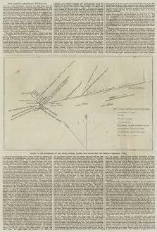
Background imageChart Collection: The Atlantic Telegraph Expedition, Chart of the Movements of the Great Eastern during the Search

The Atlantic Telegraph Expedition, Chart of the Movements of the Great Eastern during the Search for the Broken
1610568 The Atlantic Telegraph Expedition, Chart of the Movements of the Great Eastern during the Search for the Broken Telegraph Cable (engraving) by English School

Background imageChart Collection: Proposed Tunnel between England and France (engraving)

Proposed Tunnel between England and France (engraving)
1609335 Proposed Tunnel between England and France (engraving) by English School, (19th century); Private Collection; (add.info.: Proposed Tunnel between England and France)

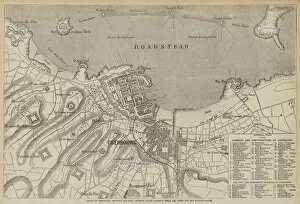
Background imageChart Collection: Chart of Cherbourg, showing the City, Arsenal, Docks, Harbour, Mole

Chart of Cherbourg, showing the City, Arsenal, Docks, Harbour, Mole, and Land and Sea Fortifications (engraving)
2771618 Chart of Cherbourg, showing the City, Arsenal, Docks, Harbour, Mole, and Land and Sea Fortifications (engraving) by English School

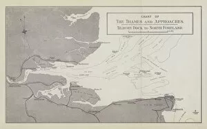
Background imageChart Collection: Chart of the Thames and Approaches, Tilbury Dock to North Foreland (litho)

Chart of the Thames and Approaches, Tilbury Dock to North Foreland (litho)
3651382 Chart of the Thames and Approaches, Tilbury Dock to North Foreland (litho) by English School, (19th century); Private Collection; (add.info.: Chart of the Thames and Approaches)

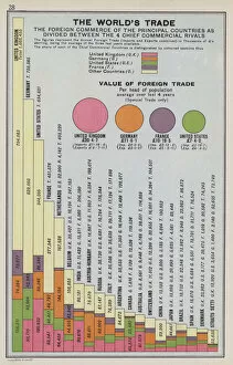
Background imageChart Collection: The worlds trade (colour litho)

The worlds trade (colour litho)
3648955 The worlds trade (colour litho) by English School, (20th century); Private Collection; (add.info.: The worlds trade)

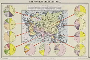
Background imageChart Collection: The worlds markets, Asia (colour litho)

The worlds markets, Asia (colour litho)
3648952 The worlds markets, Asia (colour litho) by English School, (20th century); Private Collection; (add.info.: The worlds markets, Asia)

Background imageChart Collection: The worlds markets, Europe (colour litho)

The worlds markets, Europe (colour litho)
3648950 The worlds markets, Europe (colour litho) by English School, (20th century); Private Collection; (add.info.: The worlds markets, Europe)

Background imageChart Collection: The world, coinage and currencies, The world, tariffs (colour litho)

The world, coinage and currencies, The world, tariffs (colour litho)
3648938 The world, coinage and currencies, The world, tariffs (colour litho) by English School, (20th century); Private Collection; (add.info.: The world, coinage and currencies, The world, tariffs)

Background imageChart Collection: The world, principal sailing tracks, winds and occupations (colour litho)

The world, principal sailing tracks, winds and occupations (colour litho)
3648934 The world, principal sailing tracks, winds and occupations (colour litho) by English School, (20th century); Private Collection; (add.info.: The world, principal sailing tracks)

Background imageChart Collection: Ivory, gums, resin and wax (colour litho)

Ivory, gums, resin and wax (colour litho)
3648671 Ivory, gums, resin and wax (colour litho) by English School, (20th century); Private Collection; (add.info.: Ivory, gums, resin and wax)

Background imageChart Collection: Timber, growing countries (colour litho)

Timber, growing countries (colour litho)
3648670 Timber, growing countries (colour litho) by English School, (20th century); Private Collection; (add.info.: Timber, growing countries)


All Professionally Made to Order for Quick Shipping

"Unlocking the Secrets: Exploring the Fascinating World of Charts" Dive into the realm of reflexology with a detailed foot map chart, revealing hidden connections between pressure points and overall well-being. Immerse yourself in breathtaking artwork as "Kiss of the Oceans" captures the meeting point between Atlantic and Pacific through a mesmerizing chart inspired by the Panama Canal. Travel back in time with a captivating map showcasing the vast Ancient Persian Empire, unraveling its grandeur and historical significance. Follow in the footsteps of greatness as you trace King Alexander the Great's conquests on an intricate chart mapping his empire's expansion across continents. Join forces with The Salvation Army Campaign through their emblematic chart, highlighting their noble mission to bring hope and aid to those in need. Unveil Masonic mysteries through an enchanting chart that delves into both symbolic imagery and rich history surrounding Free and Accepted Masons. Embark on a journey through time with a remarkable Masonic chart, shedding light on ancient rituals, traditions, and brotherhood within this enigmatic society. Explore distant lands from centuries past as an Anglo-Saxon 10th-century world map unfolds before your eyes, offering insights into early cartography techniques. Discover rugged beauty amidst towering peaks with an old map of the Alps; let it guide you through nature's wonders while tracing historic routes taken by explorers long ago. Gain strategic insight during WWII using a military-focused map of Beirut, Lebanon; uncover hidden locations crucial for wartime operations throughout this historically significant cityscape. Step back in time to 1768 Edinburgh as James Craig's Map reveals New Town's first plan—a testament to meticulous topography shaping Scotland's capital cityscape over centuries. Test your vision acuity against an eye-catching eyesight test chart; decipher letters or symbols while appreciating the importance of visual health in our daily lives.